

Walks around Padstow
Enjoy the walks by being guided by the app


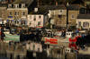
Padstow is on the site of a mediaval monastery that was raided by the vikings. The sheltered estuary of the River Camel was one of the only safe harbours on the rugged Atlantic coast so it became a port town. In Victorian times it was connected to the railway network which boosted the fishing fleet and tourism flourished. A few celebrity chefs later, it is now one of the foodie hotspots in the UK. The sheltered beaches in the estuary contrast the more rugged coastline either side.
-
1.9 miles/3 km - Easy
Park Head and Pentire Steps

Park Head and Pentire Steps
1.9 miles/3 km - Easy
A circular walk on Park Head, used as one of the filming locations in the Poldark BBC TV series and with spectacular views over Bedruthan Steps and the Trescore Islands.
-
2 miles/3.2 km - Easy
Trevose Head (short version)

Trevose Head (short version)
2 miles/3.2 km - Easy
A circular walk around the rugged coastline of Trevose Head via the iconic lighthouse and golden sandy beach at Mother Ivey's Bay, with spectacular wildflowers in spring and summer and thundering waves in winter that sometimes expose the shipwreck at Booby's Bay.
-
2.5 miles/4 km - Easy-moderate
Stepper Point and the Doom Bar

Stepper Point and the Doom Bar
2.5 miles/4 km - Easy-moderate
A circular walk overlooking the infamous Doom Bar - from which the internationally popular beer is named - on which hundreds of vessels were wrecked when attempting to navigate into Padstow harbour and many still lie beneath the sands
-
3.1 miles/5 km - Easy-moderate
Padstow to Harbour Cove

Padstow to Harbour Cove
3.1 miles/5 km - Easy-moderate
A circular walk through Padstow's mediaeval network of streets to the church, the Elizabethan Manor at Prideaux Place and Tregirls Farm, with panoramic views of the estuary, returning along a mile of sandy beaches.
-
3.8 miles/6.1 km - Easy-moderate
St Issey to Sea Mills

St Issey to Sea Mills
3.8 miles/6.1 km - Easy-moderate
A circular walk from St Issey along the river valley, the Saint's Way to the creek-side church at Little Petherick, and along the creek to the tidal enclosure of Sea Mills, returning via two old inns.
-
4.9 miles/7.9 km - Easy-moderate
Constantine Bay to Porthcothan

Constantine Bay to Porthcothan
4.9 miles/7.9 km - Easy-moderate
A circular walk between Constantine Bay to Porthcothan via nature's swimming pool at Treyarnon beach and a spectacular series of islands, headlands and tiny coves named after wine and pepper smuggled there, and the rock where a customs officer was left by smugglers to drown.
-
6.1 miles/9.7 km - Easy-moderate
Trevose Head

Trevose Head
6.1 miles/9.7 km - Easy-moderate
A circular walk around the rugged coastline of Trevose Head via the iconic lighthouse and golden sandy bays of Constantine, Booby's, Mother Ivey's and Harlyn, with spectacular wildflowers in spring and summer.
-
6.4 miles/10.3 km - Easy-moderate
Daymer Bay to Padstow

Daymer Bay to Padstow
6.4 miles/10.3 km - Easy-moderate
A figure-of-8 walk from Daymer Bay thorough the dunes to Rock, passing the once-buried St Enodoc church, before crossing on the ferry to Padstow, and returning along three miles of sandy beaches.
-
6.8 miles/10.9 km - Easy-moderate
Seven Bays (via bus)

Seven Bays (via bus)
6.8 miles/10.9 km - Easy-moderate
A one-way coastal walk, made circular via an initial bus journey, along the Seven Bays coast and around Trevose Head past the lighthouse.
-
3.5 miles/5.6 km - Moderate
Padstow town

Padstow town
3.5 miles/5.6 km - Moderate
A short circular walk from Padstow harbour to the viewpoints at the War Memorial and Victorian obelisk, the Elizabethan Manor at Prideaux Place, and including some pretty backstreets that lie off the main tourist routes.
-
4.5 miles/7.3 km - Moderate
Bedruthan Steps

Bedruthan Steps
4.5 miles/7.3 km - Moderate
A circular walk with spectacular views of the rock stacks at Bedruthan Steps, about which the myth of a giant's stepping stones was concocted for the amusement of Victorian tourists flocking to Padstow and Newquay on the new railway.
-
5.3 miles/8.6 km - Moderate
Little Petherick Creek and the Camel Trail

Little Petherick Creek and the Camel Trail
5.3 miles/8.6 km - Moderate
A circular walk via the Victorian obelisk overlooking Padstow, the creek-side church at Little Petherick and the tidal enclosure of Sea Mills, returning via the Camel Trail bridge which carried the railway that brought the first Victorian tourists to Padstow and Cornish fish to London.
-
6.2 miles/10 km - Moderate
Bedruthan Steps to Porthcothan

Bedruthan Steps to Porthcothan
6.2 miles/10 km - Moderate
A circular walk featuring some of the most spectacular scenery of the North Cornish coast including the rock stacks of Bedruthan Steps, the azure lagoon of the Trescore Islands and the sheltered golden sandy beach at Porthcothan.
-
6.7 miles/10.7 km - Moderate
Harlyn Bay to Padstow (via bus)

Harlyn Bay to Padstow (via bus)
6.7 miles/10.7 km - Moderate
A one-way coastal walk, made circular via an initial bus journey, from Harlyn Bay to Padstow via Trevone, Stepper Point - where a huge stone tower stands as a daymark, the Doom Bar and the sandy coves of Hawker's, Harbour and St George's which join into a single huge beach at low tide.
-
6.8 miles/11.0 km - Moderate
Porthcothan, Bedruthan Steps and Watergate Bay (via bus)
Porthcothan, Bedruthan Steps and Watergate Bay (via bus)
6.8 miles/11.0 km - Moderate
A (bus-assisted) one-way walk along the coast with spectacular wildflowers and one of Cornwall's most photographed views over the volcanic rock stacks of Bedruthan Steps, which Victorians liked to think of as a giant's stepping stones.
-
7.4 miles/12.1 km - Moderate
Trevone to Padstow

Trevone to Padstow
7.4 miles/12.1 km - Moderate
A circular walk to Padstow from Trevone beach, which tracks the route taken by sailing ships along the rugged Atlantic coast to the daymark at Stepper Point, past the infamous Doom Bar and the sandbanks of Hawker's, Harbour and St George's coves before finally reaching safe harbour in Padstow.


Download the iWalk Cornwall app and use the QR scanner within the app to find out more about any of the walks above.
The land around Padstow is relatively flat for North Cornwall, so although many of our walks in this area are reasonably long, you can cover the ground quite fast.
For walks that start and end in Padstow, there are short walks around Padstow Town to the memorial and obelisk, to Harbour Cove and a longer walk around Little Petherick Creek.
For a walk to combine with visiting Padstow, either the Daymer to Padstow or Trevone to Padstow pass Prideaux Place, the harbour and include the Padstow beaches. There are also walks on the other side of the Camel Estuary around Rock and Polzeath accessible via the ferry.
