

Walks in Cornwall with gorse
Enjoy the walks by being guided by the app


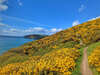
These walks usually have nice displays of gorse flowers in late March and April. The cococut-scented flowers can be used to make a cordial or flavour wine.
-
6 miles/9.6 km - Easy
Twelveheads and Chacewater

Twelveheads and Chacewater
6 miles/9.6 km - Easy
A circular walk in the Copper Kingdom of the Old World where the majority of world's copper came from during the 18th and 19th Centuries
-
3.0 miles/4.9 km - Easy-moderate
St Agnes Beacon and Wheal Coates

St Agnes Beacon and Wheal Coates
3.0 miles/4.9 km - Easy-moderate
A circular walk between St Agnes Head and the engine houses of Wheal Coates via St Agnes Beacon, with spectacular panoramic views
-
3.6 miles/5.8 km - Easy-moderate
St Newlyn East and Lappa Valley

St Newlyn East and Lappa Valley
3.6 miles/5.8 km - Easy-moderate
A circular walk from St Newlyn East through the woods of the Lappa Valley where the Steam Railway now encompasses what was one of the most famous mines in Cornwall during Victorian times and the riverbeds are still stained red.
-
3.9 miles/6.3 km - Easy-moderate
Land's End

Land's End
3.9 miles/6.3 km - Easy-moderate
A circular walk on the rugged cliffs at the most westerly point of the British mainland with spectacular views and spectacular wildflowers.
-
4 miles/6.4 km - Easy-moderate
Watergate Bay to Newquay (via bus)

Watergate Bay to Newquay (via bus)
4 miles/6.4 km - Easy-moderate
A one-way coastal walk, made circular via an initial bus journey, from Watergate Bay along the coast path to Newquay, passing the sea caves at Whipsiderry beach, the Iron Age hillfort on Trevelgue head and the beaches of Porth, Lusty Glaze and Tolcarne.
-
4.7 miles/7.6 km - Easy-moderate
Deadman's Cove to Red River Valley

Deadman's Cove to Red River Valley
4.7 miles/7.6 km - Easy-moderate
A circular walk along a coast of shipwrecks and smugglers from Deadman's Cove to Hell's Mouth, past the collapse of the North Cliffs that went viral on YouTube, and returning through the nature reserve along the Red River Valley.
-
2.9 miles/4.7 km - Moderate
Port Quin to Lundy Bay

Port Quin to Lundy Bay
2.9 miles/4.7 km - Moderate
A circular walk from the fishing village of Port Quin to the golden sandy beaches of Epphaven Cove and Lundy Bay with spectacular coastal scenery, via the cliff-edge folly on Doyden Point built as a gambling den.
-
3.2 miles/5.1 km - Moderate
Lizard to Kynance Cove (shorter version)

Lizard to Kynance Cove (shorter version)
3.2 miles/5.1 km - Moderate
A circular walk from Lizard village to Kynance Cove with spectacular views, wildflowers including Cornwall's county flower and wildlife including the Cornish Chough.
-
3.3 miles/5.3 km - Moderate
Boscastle Headlands

Boscastle Headlands
3.3 miles/5.3 km - Moderate
A circular walk from Boscastle to Pentargon waterfall and Willapark coastguard lookout with magnificent views of the village and harbour from the headlands where the village women once gathered dressed in red to fool a French ship into fleeing from British army redcoats.
-
3.3 miles/5.3 km - Moderate
Readymoney Cove to Polridmouth

Readymoney Cove to Polridmouth
3.3 miles/5.3 km - Moderate
A circular walk in du Maurier country from Readymoney Cove - where she lived in the 1940s - to Polridmouth, where the shipwreck inspired her book Rebecca.
-
3.7 miles/6 km - Moderate
St Just to Cape Cornwall

St Just to Cape Cornwall
3.7 miles/6 km - Moderate
A circular walk from St Just to the rugged coast of England's only Cape topped by a monument fashioned from a mine chimney, passing mediaeval and prehistoric remains.
-
3.8 miles/6.1 km - Moderate
Porth Nanven to Nanquidno

Porth Nanven to Nanquidno
3.8 miles/6.1 km - Moderate
A circular walk from the Cot Valley past the beaches of Nanquidno and Porth Nanven where granite boulders polished over millions of years by prehistoric oceans and then buried by the soil are being exposed once again by the sea.
-
3.8 miles/6.1 km - Moderate
St Endellion to Port Isaac

St Endellion to Port Isaac
3.8 miles/6.1 km - Moderate
A figure-of-8 walk from St Endellion to Port Isaac, via the estate of the ancient family of Roscarrock, who survived torture on the rack during Tudor times for being Catholic sympathisers, returning to the parish church, dedicated to the daughter of a Celtic king, on the ancient route which itself influenced the fervent adoption of Methodism in Port Isaac.
-
3.9 miles/6.3 km - Moderate
Perranuthnoe to Prussia Cove
")
Perranuthnoe to Prussia Cove
3.9 miles/6.3 km - Moderate
A circular walk along Mount's Bay from the large sandy beach at Perranuthnoe to the smugglers' coves at Prussia Cove, returning across the fields with views over St Michael's Mount.
-
4.0 miles/6.5 km - Moderate
Pendeen to Portheras Cove

Pendeen to Portheras Cove
4.0 miles/6.5 km - Moderate
A circular walk from Pendeen via the Geevor and Levant mines to the lighthouse at Pendeen Watch, returning via the white, sandy beach at Portheras Cove.
-
4.2 miles/6.7 km - Moderate
The Rumps to Polzeath around Pentire Point

The Rumps to Polzeath around Pentire Point
4.2 miles/6.7 km - Moderate
A circular walk across the Iron Age hillfort on the twin headlands of The Rumps and around Pentire Point, with panoramic views of the Camel Estuary and the offshore islands, to the sandy beach at Polzeath.
-
4.4 miles/7.1 km - Moderate
The Lizard and Kynance Cove

The Lizard and Kynance Cove
4.4 miles/7.1 km - Moderate
A circular walk along the Victorian Excursion route from Lizard village to the most southerly point and along the coast path to Kynance Cove with spectacular views, wildflowers, and wildlife including the Cornish Chough.
-
4.7 miles/7.6 km - Moderate
Fowey to Polridmouth

Fowey to Polridmouth
4.7 miles/7.6 km - Moderate
A figure-of-eight walk from Readymoney Cove past the Tudor fort and along the coast where Daphne du Maurier lived to Polridmouth, where the shipwreck inspired the end of her book Rebecca, and then along the mediaeval streets of Fowey.
-
4.9 miles/7.9 km - Moderate
Gorran Haven to Dodman Point

Gorran Haven to Dodman Point
4.9 miles/7.9 km - Moderate
A circular walk in the bays of Mevagissey and Veryan from the fishing village of Gorran Haven to the remote, sandy Hemmick Beach via The Deadman's Point of old nautical maps, still marked with a huge cross to warn sailors of the perilous lee shores, and Vault Beach where the wreckage washed ashore.
-
5.0 miles/8.1 km - Moderate
Hell's Mouth to Godrevy

Hell's Mouth to Godrevy
5.0 miles/8.1 km - Moderate
A circular walk following the coast from Hell's Mouth past Godrevy lighthouse to the sandy beaches of St Ives Bay, returning via a pilgrimage route along the Red River Valley.
-
5.3 miles/8.6 km - Moderate
Kit Hill to Kelly Bray

Kit Hill to Kelly Bray
5.3 miles/8.6 km - Moderate
A circular walk in Kit Hill Country Park, given to the county by the Duchy to mark the birth of Prince William and where a midsummer bonfire is lit to celebrate the ancient Celtic Golowan festival
-
5.3 miles/8.6 km - Moderate
Little Petherick Creek and the Camel Trail

Little Petherick Creek and the Camel Trail
5.3 miles/8.6 km - Moderate
A circular walk via the Victorian obelisk overlooking Padstow, the creek-side church at Little Petherick and the tidal enclosure of Sea Mills, returning via the Camel Trail bridge which carried the railway that brought the first Victorian tourists to Padstow and Cornish fish to London.
-
5.5 miles/8.7 km - Moderate
Boscastle to Tintagel (via bus)

Boscastle to Tintagel (via bus)
5.5 miles/8.7 km - Moderate
A one-way coastal walk, made circular via an initial bus journey, along the dramatic coastline of islands and arches from Boscastle to Tintagel, rated as one of the top five walks in Cornwall.
-
5.6 miles/9.0 km - Moderate
St Clether to the Rising Sun

St Clether to the Rising Sun
5.6 miles/9.0 km - Moderate
A figure-of-8 walk from St Clether past the ancient chapel and holy well, with views over the Inny Valley, to the Rising Sun pub near Altarnun, serving beer made from the moorland springwater by a local micro-brewery.
-
5.9 miles/9.5 km - Moderate
Trewarmett to Tregardock

Trewarmett to Tregardock
5.9 miles/9.5 km - Moderate
A circular walk to the remote sandy beach at Tregardock, returning along the coast path with panoramic views of Port Isaac Bay, through the wildflowers of Treligga Downs and via Backways Cove.
-
6 miles/9.7 km - Moderate
Sennen Cove, Land's End and Nanjizal

Sennen Cove, Land's End and Nanjizal
6 miles/9.7 km - Moderate
A circular walk from the white sandy beach at Sennen Cove along the towering granite cliffs via Land's End to the song of the sea cave at Nanjizal. The best way to see Land's End.
-
6.2 miles/10 km - Moderate
Boscastle to Rocky Valley

Boscastle to Rocky Valley
6.2 miles/10 km - Moderate
A circular walk from Boscastle along the dramatic coastline of islands and arches towards Tintagel, following the cascading river up Rocky Valley past the ruined mills and labyrinthine carvings and returning via the mediaeval churches of Trethevy, Trevalga and Forrabury.
-
6.2 miles/10 km - Moderate
Chapel Porth to Trevaunance Cove

Chapel Porth to Trevaunance Cove
6.2 miles/10 km - Moderate
A circular walk along the coast between the golden sandy beaches of Chapel Porth and Trevaunance Cove at St Agnes via the iconic engine houses of Wheal Coates, perched above the breakers.
-
7.1 miles/11.5 km - Moderate
Portheras Cove and Chûn Quoit
Portheras Cove and Chûn Quoit
7.1 miles/11.5 km - Moderate
A circular walk along the coast to the white, sandy beach of Portheras Cove and across the Penwith Moors to a prehistoric tomb the age of the Egyptian Pyramids
-
7.4 miles/11.8 km - Moderate
St Just to Nanquidno

St Just to Nanquidno
7.4 miles/11.8 km - Moderate
A circular walk from St Just to Cape Cornwall and the Cot Valley, where an ancient beach has been eroded from the cliffs at Porth Nanven, releasing granite boulders resembling Dinosaur eggs.
-
7.4 miles/12.1 km - Moderate
Trevone to Padstow

Trevone to Padstow
7.4 miles/12.1 km - Moderate
A circular walk to Padstow from Trevone beach, which tracks the route taken by sailing ships along the rugged Atlantic coast to the daymark at Stepper Point, past the infamous Doom Bar and the sandbanks of Hawker's, Harbour and St George's coves before finally reaching safe harbour in Padstow.
-
3.8 miles/6.2 km - Moderate-strenuous
Morwenstow to Stanbury Mouth

Morwenstow to Stanbury Mouth
3.8 miles/6.2 km - Moderate-strenuous
A circular walk from Morwenstow along the shipwreck coast to Stanbury Mouth where only nature's by-the-wind sailors now run aground
-
4.2 miles/6.8 km - Moderate-strenuous
Rosemergy to Gurnard's Head

Rosemergy to Gurnard's Head
4.2 miles/6.8 km - Moderate-strenuous
A circular walk along the coast past the towering cliffs of Bosigran Castle via the white sand and huge boulders of Porthmeor Cove to the site of an Iron Age fort on Gurnard's Head, returning from the Gurnard's Head pub via the ancient Zennor Churchway.
-
4.3 miles/6.9 km - Moderate-strenuous
Crackington Haven to The Strangles

Crackington Haven to The Strangles
4.3 miles/6.9 km - Moderate-strenuous
A circular walk from Crackington Haven, with panoramic views of the Shipwreck Coast, to the long, sandy Strangles beach, returning through bluebell woodland along the Ludon river valley.
-
4.8 miles/7.7 km - Moderate-strenuous
Port Quin to Port Isaac

Port Quin to Port Isaac
4.8 miles/7.7 km - Moderate-strenuous
A circular walk along the rollercoaster path from Port Quin, descending into Port Isaac, with spectacular views of the harbour, via the old houses of Roscarrock Hill including Doc Martin's, one with roof timbers tied on by an anchor chain, and the Sunday School with a bell from a shipwreck.
-
5.3 miles/8.5 km - Moderate-strenuous
Pentewan, Heligan and Mevagissey

Pentewan, Heligan and Mevagissey
5.3 miles/8.5 km - Moderate-strenuous
A circular walk from Pentewan to Mevagissey via The Lost Gardens of Heligan which were discovered in the 1990s after 7 decades of neglect and what followed The Times described as the garden restoration of the century.
-
5.4 miles/8.7 km - Moderate-strenuous
Boscastle to Buckator

Boscastle to Buckator
5.4 miles/8.7 km - Moderate-strenuous
A circular walk along the coastline from Boscastle via the Pentargon waterfall and the rugged cliffs at Buckator, returning along the Valency valley.
-
5.4 miles/8.6 km - Moderate-strenuous
Duckpool to Woodford

Duckpool to Woodford
5.4 miles/8.6 km - Moderate-strenuous
A circular walk in Morwenstow parish along towering cliffs and through broadleaf woods where a hamlet has been preserved in a joint project between the Landmark Trust and National Trust
-
6 miles/9.6 km - Moderate-strenuous
Seaton to Millendreath

Seaton to Millendreath
6 miles/9.6 km - Moderate-strenuous
A circular walk in an area of Cornwall so off the beaten track that No Man's Land is a real place name and a breeding colony of monkeys live in the woodland, in a sanctuary set up by the father of the classical guitarist, John Williams.
-
6.7 miles/10.8 km - Moderate-strenuous
Polkerris, Gribbin Head and Readymoney Cove

Polkerris, Gribbin Head and Readymoney Cove
6.7 miles/10.8 km - Moderate-strenuous
A circular walk near Fowey, from the tiny harbour of Polkerris, past the daymark tower on Gribbin Head and along the coast where Daphne du Maurier lived and based many of her books on, to the sandy beach at Readymoney Cove, returning on the Saint's Way.
-
6.8 miles/10.9 km - Moderate-strenuous
Talland Bay to Looe

Talland Bay to Looe
6.8 miles/10.9 km - Moderate-strenuous
A circular walk along the coast from Talland Bay to Looe, passing the pilgrimage site of Looe Island which Jesus was said to have visited as a child, and returning via the ancient Giant's Hedge in Kilminorth Wood and Talland's mediaeval church.
-
7.3 miles/11.8 km - Moderate-strenuous
Coverack to Lankidden Cove

Coverack to Lankidden Cove
7.3 miles/11.8 km - Moderate-strenuous
A circular walk on one of the most remote parts of The Lizard from Coverack to the white sand beaches of Downas and Lankidden Coves, where the serpentine underwater landscape provides some of the best snorkelling in Cornwall.
-
9.9 miles/15.9 km - Moderate-strenuous
Port Isaac to Polzeath (via bus)

Port Isaac to Polzeath (via bus)
9.9 miles/15.9 km - Moderate-strenuous
A one-way coastal walk, made circular via an initial bus journey, from Port Isaac to Polzeath along the Rollercoaster Path to Port Quin, the golden beaches of Lundy Bay via the Iron Age hillfort on the twin headland of The Rumps.
-
4 miles/6.4 km - Strenuous
Tregardock to Dannonchapel

Tregardock to Dannonchapel
4 miles/6.4 km - Strenuous
A circular walk from Tregardock, passing the long, remote sandy beach, to the ruins of the mediaeval manor of Dannonchapel, and includes one of the steepest and most spectacular sections of the North Cornish Coast path with vibrant wildflowers in spring and summer.
-
4.4 miles/7 km - Strenuous
Morwenstow to Marsland

Morwenstow to Marsland
4.4 miles/7 km - Strenuous
A circular walk from Vicarage Cliff along the coast path to Marsland Mouth at the Devon border, returning through fields to Morwenstow rectory, church and the Rectory Tearooms - the last stand of the Cornish cream tea before the Devon border.
-
4.5 miles/7.3 km - Strenuous
St Gennys Church to Dizzard

St Gennys Church to Dizzard
4.5 miles/7.3 km - Strenuous
A circular walk at St Gennys from the mediaeval church, via the smuggling routes though bluebell woods along the stream and an Iron Age clifftop fort crumbling into the sea, to some of North Cornwall's most remote coastline.
-
6.4 miles/10.3 km - Strenuous
Crackington Haven to Widemouth (via bus)

Crackington Haven to Widemouth (via bus)
6.4 miles/10.3 km - Strenuous
A one-way coastal walk, made circular via an initial bus journey, along the Shipwreck Coast from Crackington Haven to Widemouth Bay passing the bluebell woodland of ancient twisted oaks at The Dizzard, chevron folded rocks and honeycomb reefs of Millook Haven and fossil beds of Wanson Mouth.
-
7.1 miles/11.5 km - Strenuous
Polperro to Lansallos

Polperro to Lansallos
7.1 miles/11.5 km - Strenuous
A circular walk along the rugged coast from Polperro, where a bell buoy rings out across the waves from the treacherous reef known as Udder Rock.


")


Download the iWalk Cornwall app and use the QR scanner within the app to find out more about any of the walks above.
