

Walks in Cornwall with a low chance of encountering livestock
Enjoy the walks by being guided by the app


Please note this is only a best guess from the landscape that livestock are less likely on these routes than others - it not a guarantee as livestock are moved around and sometimes used to graze the coast and parkland.
-
2 miles/3.2 km - Easy
Trevose Head (short version)

Trevose Head (short version)
2 miles/3.2 km - Easy
A circular walk around the rugged coastline of Trevose Head via the iconic lighthouse and golden sandy beach at Mother Ivey's Bay, with spectacular wildflowers in spring and summer and thundering waves in winter that sometimes expose the shipwreck at Booby's Bay.
-
2.5 miles/4 km - Easy
Botallack Head

Botallack Head
2.5 miles/4 km - Easy
A circular walk around Cornwall's most iconic mining remains, used for the filming of the BBC's Poldark series
-
2.7 miles/4.3 km - Easy
Hayle and The Towans

Hayle and The Towans
2.7 miles/4.3 km - Easy
A circular walk on the Towans at Hayle, where Cornwall's beam engines were cast using sand from a prehistoric lagoon when West Penwith was an island.
-
2.9 miles/4.7 km - Easy
Helston

Helston
2.9 miles/4.7 km - Easy
A circular walk at Helston along the wooded valley of the River Cober and through the town via the church.
-
3.2 miles/5.2 km - Easy
King's Wood and Pentewan Valley

King's Wood and Pentewan Valley
3.2 miles/5.2 km - Easy
A circular walk through the King's Wood Woodland Trust reserve to the lost port of Pentewan, along the trackbed of the horse-drawn tramway that once carried china clay to the busy port and via the system of reservoirs and sluices that were used to flush sand out of the harbour.
-
3.5 miles/5.6 km - Easy
Par and Tywardreath

Par and Tywardreath
3.5 miles/5.6 km - Easy
A circular walk at Tywardreath where a mediaeval Priory was based and Par where much of the route was once a tidal creek and a wetland nature reserve has been created on some of the reclaimed land.
-
3.9 miles/6.3 km - Easy
Bude Canal and Coast

Bude Canal and Coast
3.9 miles/6.3 km - Easy
A figure-of-8 walk at Bude where the demand for lime-rich sand could not even be met by 4000 horses a day and so a 35-mile canal was built to transport it to the Tamar Valley.
-
4.4 miles/7.1 km - Easy
Truro and the old Newham railway

Truro and the old Newham railway
4.4 miles/7.1 km - Easy
A circular walk at Truro along the river, trackbed of the Newham railway and through the historic city centre.
-
6 miles/9.7 km - Easy
Marazion to Penzance
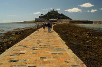
Marazion to Penzance
6 miles/9.7 km - Easy
A circular walk around Mount's Bay where the remains of the prehistoric forest that surrounded St Michael's Mount can still occasionally be seen on very low tides after storms
-
6 miles/9.6 km - Easy
Twelveheads and Chacewater

Twelveheads and Chacewater
6 miles/9.6 km - Easy
A circular walk in the Copper Kingdom of the Old World where the majority of world's copper came from during the 18th and 19th Centuries
-
2.2 miles/3.6 km - Easy-moderate
West Pentire and Polly Joke

West Pentire and Polly Joke
2.2 miles/3.6 km - Easy-moderate
A circular walk through the poppy fields of West Pentire to Polly Joke beach, returning over the headland to the pub that was a cowshed until the mid-20th Century.
-
2.4 miles/3.8 km - Easy-moderate
Gwithian and Upton Towans

Gwithian and Upton Towans
2.4 miles/3.8 km - Easy-moderate
A circular walk around the nature reserve in the sand dunes that was once the National Explosives Works where young girls manufactured dynamite from nitroglycerine, two tonnes of which detonated causing a shock wave that broke windows in St Ives and Penzance and could be heard on Dartmoor.
-
2.7 miles/4.4 km - Easy-moderate
Gwennap Pit to Carn Marth (short version)

Gwennap Pit to Carn Marth (short version)
2.7 miles/4.4 km - Easy-moderate
A circular walk at Carn Marth with panoramic views right across mid-Cornwall to Falmouth and the Roseland, the Cornish Alps and Bodmin Moor, and St Agnes and Trevose Head
-
3 miles/4.8 km - Easy-moderate
Looe woodland, river and coast

Looe woodland, river and coast
3 miles/4.8 km - Easy-moderate
A walk following the West Looe river from woods to its confluence and then to meet the Atlantic beside one of Cornwall's mediaeval ports.
-
3.1 miles/5 km - Easy-moderate
Padstow to Harbour Cove

Padstow to Harbour Cove
3.1 miles/5 km - Easy-moderate
A circular walk through Padstow's mediaeval network of streets to the church, the Elizabethan Manor at Prideaux Place and Tregirls Farm, with panoramic views of the estuary, returning along a mile of sandy beaches.
-
3.2 miles/5.1 km - Easy-moderate
Lanhydrock Gardens

Lanhydrock Gardens
3.2 miles/5.1 km - Easy-moderate
A fairly short and easy circular walk through Lanhydrock gardens with plenty of picnic spots along the River Fowey that you can combine with a visit to the house.
-
3.3 miles/5.3 km - Easy-moderate
Penrose to the Loe Bar

Penrose to the Loe Bar
3.3 miles/5.3 km - Easy-moderate
A circular walk alongside the Loe Pool to the Loe Bar and back via the farm on the hill spur, which in Cornish gave the name to the Penrose Estate.
-
3.4 miles/5.5 km - Easy-moderate
Luxulyan Valley circular

Luxulyan Valley circular
3.4 miles/5.5 km - Easy-moderate
A circular walk following the leats and horse-drawn tramways through the World Heritage site of the Luxulyan Valley to the massive viaduct which carried the tramways towards Newquay and water to winch the trams up the valley with a huge waterwheel, recommended in guidebooks as early as the 1920s "as one of the most glorious walks in all Cornwall".
-
3.4 miles/5.4 km - Easy-moderate
Wheal Maid and Poldice Valley

Wheal Maid and Poldice Valley
3.4 miles/5.4 km - Easy-moderate
A circular walk in the area described in Victorian times as the richest square mile anywhere on Earth
-
3.6 miles/5.8 km - Easy-moderate
Lost Church and Perranporth dunes

Lost Church and Perranporth dunes
3.6 miles/5.8 km - Easy-moderate
A circular walk on the highest dune system in Britain to the chapel dating from Celtic times which was lost in the dunes for nearly 1000 years.
-
3.7 miles/6.0 km - Easy-moderate
Calstock

Calstock
3.7 miles/6.0 km - Easy-moderate
A walk at Calstock where a Victorian mineral railway from Kelly Bray once ran down to the quayside and the viaduct was built in the 1900s to connect this to Plymouth, creating today's Tamar Valley Line.
-
3.7 miles/5.9 km - Easy-moderate
Lerryn River and Tivoli lost gardens

Lerryn River and Tivoli lost gardens
3.7 miles/5.9 km - Easy-moderate
A woodland and riverside walk at Lerryn - thought to be the inspiration for the book The Wind In The Willows - and the lost pleasure gardens of Tivoli Park
-
3.8 miles/6.1 km - Easy-moderate
Lanhydrock to Respryn

Lanhydrock to Respryn
3.8 miles/6.1 km - Easy-moderate
A circular walk through the mature broadleaf woodland in the less well-known areas of the Lanhydrock estate, through bluebell woods and along the River Fowey, past the mediaeval bridge at Respryn, built after numerous prayers for safe passage in the ford-side chapel, had not resulted in the desired outcome.
-
3.9 miles/6.3 km - Easy-moderate
Penzance to Newlyn

Penzance to Newlyn
3.9 miles/6.3 km - Easy-moderate
A circular walk at Mount's Bay from the largest port town in the bay to the harbour of Cornwall's largest fishing fleet.
-
4 miles/6.4 km - Easy-moderate
Watergate Bay to Newquay (via bus)

Watergate Bay to Newquay (via bus)
4 miles/6.4 km - Easy-moderate
A one-way coastal walk, made circular via an initial bus journey, from Watergate Bay along the coast path to Newquay, passing the sea caves at Whipsiderry beach, the Iron Age hillfort on Trevelgue head and the beaches of Porth, Lusty Glaze and Tolcarne.
-
4.7 miles/7.6 km - Easy-moderate
Trelissick

Trelissick
4.7 miles/7.6 km - Easy-moderate
A figure-of-8 walk along the creeks of the River Fal through the 300 acre estate surrounding Trelissick House.
-
4.8 miles/7.7 km - Easy-moderate
Saltash and the Lynher Valley

Saltash and the Lynher Valley
4.8 miles/7.7 km - Easy-moderate
A circular walk in the ferry town that was the main riverside settlement in mediaeval times when Plymouth was moorland, and where a handful of Elizabethan buildings still remain from the period when Francis Drake built a property empire from his circumnavigation of the globe.
-
5 miles/8 km - Easy-moderate
St Austell, Clay Trails and Menacuddle Well

St Austell, Clay Trails and Menacuddle Well
5 miles/8 km - Easy-moderate
A circular walk in china clay country, including a trail laid on the trackbed of a mineral railway from St Austell to the Cornish Alps and one of Cornwall's most picturesque holy wells.
-
5.3 miles/8.6 km - Easy-moderate
Falmouth and Pendennis Head

Falmouth and Pendennis Head
5.3 miles/8.6 km - Easy-moderate
A circular walk around the thriving town of Falmouth, which didn't exist until Elizabethan times when Sir Walter Raleigh suggested that the largest natural harbour in Europe would be a good place to build a port town.
-
6 miles/9.6 km - Easy-moderate
Penrose and Porthleven

Penrose and Porthleven
6 miles/9.6 km - Easy-moderate
A circular walk through the woodland alongside the Loe to the most southerly port on the British mainland, famous for its huge storm waves.
-
6.1 miles/9.7 km - Easy-moderate
Trevose Head

Trevose Head
6.1 miles/9.7 km - Easy-moderate
A circular walk around the rugged coastline of Trevose Head via the iconic lighthouse and golden sandy bays of Constantine, Booby's, Mother Ivey's and Harlyn, with spectacular wildflowers in spring and summer.
-
6.2 miles/10 km - Easy-moderate
Gwennap Pit and Carn Marth

Gwennap Pit and Carn Marth
6.2 miles/10 km - Easy-moderate
A circular walk through an area steeped in mining history, with panoramic views from Carn Marth and the almost legendary Gwennap Pit which became so famous that even the neighbouring mine was renamed to Cathedral
-
2.5 miles/4 km - Moderate
Danescombe Valley

Danescombe Valley
2.5 miles/4 km - Moderate
A circular walk from Cotehele Quay into the broadleaf woodland of the Danescombe Valley where bluebells and orchids flower in spring and fungi erupt through the carpet of autumn leaves.
-
2.9 miles/4.7 km - Moderate
Polperro harbour and headlands

Polperro harbour and headlands
2.9 miles/4.7 km - Moderate
A figure-of-eight walk around the fishing village and headlands surrounding Polperro, passing the net loft perched above the harbour, the Victorian sea pool, the site of the mediaeval chapel and the harbourmaster's route to the lighthouse.
-
3.1 miles/4.9 km - Moderate
Kilminorth Woods and the Giant's Hedge

Kilminorth Woods and the Giant's Hedge
3.1 miles/4.9 km - Moderate
A woodland walk alongside the West Looe River where the Giant's Hedge once divided kingdoms of the Dark Ages, centuries before the ancient trees that now tower above it were even seedlings.
-
4.3 miles/7 km - Moderate
Lelant to St Ives

Lelant to St Ives
4.3 miles/7 km - Moderate
A one-way walk to St Ives along the beaches from Lelant including the vast expanse of Porthkidney Sands, Carbis Bay and Porthminster Beach using the train or bus to make the route almost circular.
-
4.7 miles/7.5 km - Moderate
Perranporth to St Agnes (via bus)

Perranporth to St Agnes (via bus)
4.7 miles/7.5 km - Moderate
A one-way coastal walk, made circular via an initial bus journey, along the ore-bearing cliffs between Perranporth and St Agnes passing the remains of Nobel's dynamite works, Britain's best preserved spitfire base and the Blue Hills of Trevellas Coombe where tin is still processed on a small scale using traditional methods.
-
4.7 miles/7.5 km - Moderate
Porthtowan to Chapel Porth

Porthtowan to Chapel Porth
4.7 miles/7.5 km - Moderate
A circular walk from Porthtowan, along the coast, valleys and woodland, passing engine houses and other relics of Cornish copper mining.
-
4.8 miles/7.7 km - Moderate
Grampound to Trenowth

Grampound to Trenowth
4.8 miles/7.7 km - Moderate
A circular walk in the Fal valley from Grampound which began as river port in Roman times which evolved into the gateway into West Cornwall in mediaeval times and went on to become the centre of Cornwall's tanning industry.
-
5.4 miles/8.7 km - Moderate
Perranporth to Trevellas

Perranporth to Trevellas
5.4 miles/8.7 km - Moderate
A circular walk past the remains of Alfred Nobel's dynamite works to the red-and-yellow ore-rich cliffs above the wreck of the treasure ship Hanover, returning, via the spitfire base, along Perran Coombe where a 2-mile leat once carried water to power a massive waterwheel in a chamber within the cliffs.
-
5.8 miles/9.3 km - Moderate
Newquay

Newquay
5.8 miles/9.3 km - Moderate
A circular walk around the UK's surf capital which was transformed from a tiny fishing village with a few thatched cottages when, in order to export ore from the harbour, a horse-drawn tramway was built across Cornwall which later became part of the Great Western Railway.
-
5.9 miles/9.5 km - Moderate
Carn Brea and the Great Flat Lode

Carn Brea and the Great Flat Lode
5.9 miles/9.5 km - Moderate
A circular walk along the Great Flat Lode, where the Basset family made their fortune from the rich mineral reserves, to Carn Brea where they built a hunting lodge balanced on a tor in the style of a castle.
-
5.9 miles/9.5 km - Moderate
Cotehele to Calstock

Cotehele to Calstock
5.9 miles/9.5 km - Moderate
A circular walk through the gardens of Cotehele to Calstock where Cornwall's largest Roman fort once stood, the Vikings allied with the Cornish to fight off the Saxons, and more recently railway wagons were lifted over 100ft by steam power from the quay to the top of the viaduct.
-
6.2 miles/10 km - Moderate
Chapel Porth to Trevaunance Cove

Chapel Porth to Trevaunance Cove
6.2 miles/10 km - Moderate
A circular walk along the coast between the golden sandy beaches of Chapel Porth and Trevaunance Cove at St Agnes via the iconic engine houses of Wheal Coates, perched above the breakers.
-
6.5 miles/10.5 km - Moderate
Duloe to Herodsfoot

Duloe to Herodsfoot
6.5 miles/10.5 km - Moderate
A circular walk through the woodland along the West Looe River to Herodsfoot from Duloe, where Cornwall's smallest stone circle stands.
-
2.5 miles/3.9 km - Moderate-strenuous
Talland Bay to Polperro

Talland Bay to Polperro
2.5 miles/3.9 km - Moderate-strenuous
A circular walk between Talland Bay and Polperro along an area of coastline so famous for smuggling that there is even a museum on the subject.
-
5.2 miles/8.4 km - Moderate-strenuous
Portreath and Tehidy Woods

Portreath and Tehidy Woods
5.2 miles/8.4 km - Moderate-strenuous
A circular walk along the rugged North Cliffs hiding smuggler's coves such as Ralph's Cupboard, to the sandy beach and historic mining port of Portreath, returning via the bluebell woodland of Illogan and Tehidy Country Park.
-
7.7 miles/12.4 km - Moderate-strenuous
Zennor to St Ives (via bus)

Zennor to St Ives (via bus)
7.7 miles/12.4 km - Moderate-strenuous
A fairly demanding but rewarding one-way coastal walk, made circular via an initial bus journey, along the rugged coast between St Ives and Zennor, passing Seal Island which may have given rise to the legend of the mermaid of Zennor and - thanks to some imaginative naming - ice cream (Moomaid of Zennor). The walk is in the optimal direction to remove time pressure and for panoramic views across St Ives bay.
-
7.1 miles/11.5 km - Strenuous
Polperro to Lansallos

Polperro to Lansallos
7.1 miles/11.5 km - Strenuous
A circular walk along the rugged coast from Polperro, where a bell buoy rings out across the waves from the treacherous reef known as Udder Rock.
-
7.3 miles/11.7 km - Strenuous
Portreath to Tobban Horse

Portreath to Tobban Horse
7.3 miles/11.7 km - Strenuous
A circular walk along the rugged coast from Portreath towards Porthtowan passing small coves and remnants of the clifftop mines beside the old RAF base, and returning via the horse-drawn tramway that brought fortune to Portreath harbour, where its "lighthouse" and "monkey house" remain from the shipping activity.


Download the iWalk Cornwall app and use the QR scanner within the app to find out more about any of the walks above.
