

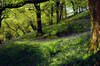
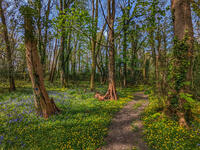
Walks in Cornwall with bluebells
Enjoy the walks by being guided by the app


These walks usually have nice displays of bluebells in April and May. Due to the mild winters in Cornwall, the bluebells usually come here before anywhere else in the UK. The first few can even sometimes be seen in the south-facing valleys at the end of March.
-
3.2 miles/5.2 km - Easy
King's Wood and Pentewan Valley

King's Wood and Pentewan Valley
3.2 miles/5.2 km - Easy
A circular walk through the King's Wood Woodland Trust reserve to the lost port of Pentewan, along the trackbed of the horse-drawn tramway that once carried china clay to the busy port and via the system of reservoirs and sluices that were used to flush sand out of the harbour. There is a nice display of bluebells down the steep bank at the back of the valley floor.
-
4.2 miles/6.8 km - Easy
Constantine to Scott's Quay
Constantine to Scott's Quay
4.2 miles/6.8 km - Easy
A circular walk at Constantine through woods and to the creek on the Helford river where a bustling quarrying and mining industry operated in Victorian times but have now been reclaimed by nature.
-
6 miles/9.6 km - Easy
Twelveheads and Chacewater

Twelveheads and Chacewater
6 miles/9.6 km - Easy
A circular walk in the Copper Kingdom of the Old World where the majority of world's copper came from during the 18th and 19th Centuries
-
2.2 miles/3.5 km - Easy-moderate
Lesnewth Church to Hallwell Woods

Lesnewth Church to Hallwell Woods
2.2 miles/3.5 km - Easy-moderate
A short circular walk in the tributary valleys of the River Valency through bluebell woodland beside a stream, and across meadows rich in wildflowers to the ancient Celtic churchyard of Lesnewth. There are bluebells in the woodland section of the walk during the spring.
-
2.7 miles/4.4 km - Easy-moderate
Blisland to Lavethan Wood

Blisland to Lavethan Wood
2.7 miles/4.4 km - Easy-moderate
A short circular walk from the village of Blisland through the churchyard, two stretches of the Woodland Trust reserve of Lavethan Wood and land which was once the estates of Lavethan and Barlandew manors. The return route through Lavethan Wood is lined with bluebells in the spring.
-
3.2 miles/5.1 km - Easy-moderate
Lanhydrock Gardens

Lanhydrock Gardens
3.2 miles/5.1 km - Easy-moderate
A fairly short and easy circular walk through Lanhydrock gardens with plenty of picnic spots along the River Fowey that you can combine with a visit to the house. There are bluebells in the woods alongside the river.
-
3.2 miles/5.1 km - Easy-moderate
Poundstock to Penfound

Poundstock to Penfound
3.2 miles/5.1 km - Easy-moderate
A circular walk along country lanes, tracks and through fields to Penfound Manor - thought to be the oldest continually-inhabited ancestral home in England - from Poundstock church and gildhouse - the only surviving mediaeval church house of its kind in Cornwall. There are bluebells along the more shady areas of footpath between Newmill and Penfound Manor.
-
3.3 miles/5.3 km - Easy-moderate
Penrose to the Loe Bar

Penrose to the Loe Bar
3.3 miles/5.3 km - Easy-moderate
A circular walk alongside the Loe Pool to the Loe Bar and back via the farm on the hill spur, which in Cornish gave the name to the Penrose Estate.
-
3.3 miles/5.2 km - Easy-moderate
St Keverne to Porthallow

St Keverne to Porthallow
3.3 miles/5.2 km - Easy-moderate
A circular walk through woods and meadows to Porthoustock and Porthallow from St Keverne, settled in the Dark Ages by Celtic monks trading with Brittany There are some nice bluebells near the start of the walk as you descend into the woods near Trenoweth Farm.
-
3.6 miles/5.8 km - Easy-moderate
St Newlyn East and Lappa Valley

St Newlyn East and Lappa Valley
3.6 miles/5.8 km - Easy-moderate
A circular walk from St Newlyn East through the woods of the Lappa Valley where the Steam Railway now encompasses what was one of the most famous mines in Cornwall during Victorian times and the riverbeds are still stained red. There are nice bluebells in Metha Wood.
-
3.7 miles/6.0 km - Easy-moderate
Calstock

Calstock
3.7 miles/6.0 km - Easy-moderate
A walk at Calstock where a Victorian mineral railway from Kelly Bray once ran down to the quayside and the viaduct was built in the 1900s to connect this to Plymouth, creating today's Tamar Valley Line.
-
3.7 miles/5.9 km - Easy-moderate
Newmills to Tregadillett

Newmills to Tregadillett
3.7 miles/5.9 km - Easy-moderate
A circular walk in the Kensey valley from the end of the steam railway at Newmills, through the bluebell woods at Trebursye, to the Eliot Arms in Tregadillett and returning to Newmills via the remains of a prehistoric fort, to catch the steam train back to Launceston. There are nice displays of bluebells in Trebursye Wood, just after you re-enter the woods from the field.
-
3.7 miles/6 km - Easy-moderate
St Just-in-Roseland to Messack Point

St Just-in-Roseland to Messack Point
3.7 miles/6 km - Easy-moderate
A circular walk on the Roseland along both sides of St Just creek to Messack Point, where there are spectacular views over one of the largest natural harbours in the world. There are bluebells along the path through the woods from Messack Point.
-
3.8 miles/6.1 km - Easy-moderate
Lanhydrock to Respryn

Lanhydrock to Respryn
3.8 miles/6.1 km - Easy-moderate
A circular walk through the mature broadleaf woodland in the less well-known areas of the Lanhydrock estate, through bluebell woods and along the River Fowey, past the mediaeval bridge at Respryn, built after numerous prayers for safe passage in the ford-side chapel, had not resulted in the desired outcome. There are bluebells in the woods alongside the river.
-
3.7 miles/5.9 km - Easy-moderate
St Mabyn to Pencarrow House

St Mabyn to Pencarrow House
3.7 miles/5.9 km - Easy-moderate
A fairly easy circular walk from St Mabyn past the church and through rolling countryside to Pencarrow House and its magnificent gardens. The are lovely bluebells in the gardens at Pencarrow, particularly in the wooded areas on the western side of the house.
-
4.3 miles/7 km - Easy-moderate
Tehidy Woods to Deadman's Cove

Tehidy Woods to Deadman's Cove
4.3 miles/7 km - Easy-moderate
A circular walk through the wildlife reserve and bluebell woodland of Tehidy Country Park to Deadman's Cove and the North Cliffs, where many sailing ships were wrecked before the Godrevy Lighthouse was built. There are some nice bluebells in the North Cliffs Plantation when you re-enter Tehidy woods towards the end of the walk.
-
4.4 miles/7 km - Easy-moderate
Giant's Quoit and Pendarves Wood

Giant's Quoit and Pendarves Wood
4.4 miles/7 km - Easy-moderate
A walk from a tiny village designed by Victorians, through ancient woodland that was once part of the Pendarves Estate to the prehistoric tomb that, despite two collapses over the centuries, is once again standing.
-
4.6 miles/7.4 km - Easy-moderate
Helford to Dennis Head

Helford to Dennis Head
4.6 miles/7.4 km - Easy-moderate
A circular walk around the creeks of the Helford River and the small villages settled by Celtic monks from Brittany.
-
4.7 miles/7.6 km - Easy-moderate
Deadman's Cove to Red River Valley

Deadman's Cove to Red River Valley
4.7 miles/7.6 km - Easy-moderate
A circular walk along a coast of shipwrecks and smugglers from Deadman's Cove to Hell's Mouth, past the collapse of the North Cliffs that went viral on YouTube, and returning through the nature reserve along the Red River Valley. The are bluebells along the route at Menadarva and along the lane at Coombe.
-
5 miles/8.1 km - Easy-moderate
Camelford to Watergate

Camelford to Watergate
5 miles/8.1 km - Easy-moderate
A circular walk from Camelford through bluebell woods along the Camel valley to the Celtic churchyard of Advent and the Neolithic remains on the edge of Bodmin Moor. There is an impressive display of bluebells in the woodland opposite Fenteroon Farm.
-
5.1 miles/8.3 km - Easy-moderate
Deerpark to Herodsfoot

Deerpark to Herodsfoot
5.1 miles/8.3 km - Easy-moderate
A woodland walk in what's likely to have been a mediaeval deer park to the site of Cornwall's second-largest gunpowder manufacturing operation, which despite exploding several times was sufficiently successful to give rise to a nearby sister site known as Trago Mills.
-
5.8 miles/9.3 km - Easy-moderate
Castle-an-dinas and Menalhyl valley

Castle-an-dinas and Menalhyl valley
5.8 miles/9.3 km - Easy-moderate
A mostly circular walk from the Castle-an-dinas Iron Age hillfort with 360 degree views across Cornwall, then into the valley to the River Menalhyl, followed by wooded paths lined with primroses, bluebells and wild garlic, and lanes with vibrant wildflowers. There are bluebells along the path leading up from the river to Trewolvas.
-
5.8 miles/9.4 km - Easy-moderate
Rosemullion Head

Rosemullion Head
5.8 miles/9.4 km - Easy-moderate
A circular walk passing the National Trust's Glendurgan gardens and the equally spectacular submarine gardens of Rosemullion Head where fish dart amongst the brightly-coloured blooms.
-
6 miles/9.6 km - Easy-moderate
Penrose and Porthleven

Penrose and Porthleven
6 miles/9.6 km - Easy-moderate
A circular walk through the woodland alongside the Loe to the most southerly port on the British mainland, famous for its huge storm waves.
-
6.1 miles/9.7 km - Easy-moderate
Egloshayle to Dinham Bridge

Egloshayle to Dinham Bridge
6.1 miles/9.7 km - Easy-moderate
A circular walk in the Allen Valley from Egloshayle though the broadleaf woodland alongside the River Allen past the mills of Hingham and Lemail, returning via the Celtic Three Holed Cross and the remains of Castle Killibury which from mediaeval Welsh texts is thought might be one of King Arthur's several castles. There are often some nice displays of bluebells just after Lemail Mill as you ascend the Allen Valley from Hingham Mill.
-
6.2 miles/10 km - Easy-moderate
The Loe

The Loe
6.2 miles/10 km - Easy-moderate
A circular walk around the Loe Pool, the largest natural freshwater lake in Cornwall, and along the Loe Bar, one of Cornwall's most treacherous beaches on which 100 of those onboard the HMS Anson drowned metres from the shore, motivating the invention of the rocket lifesaving apparatus that saved thousands of lives.
-
6.5 miles/10.5 km - Easy-moderate
Budock Water and the Lakes

Budock Water and the Lakes
6.5 miles/10.5 km - Easy-moderate
A walk from what was once the parish church for Falmouth to the lakes in a river valley which the Celtic people described as secluded and where Argal Mill lies somewhere beneath the water in a Cornish version of Atlantis.
-
6.6 miles/10.7 km - Easy-moderate
St Mawgan to St Columb Major

St Mawgan to St Columb Major
6.6 miles/10.7 km - Easy-moderate
A circular walk along the Vale of Lanherne to the mediaeval market town of St Columb Major, where Cornish Hurling is still played, through the broadleaf woodland of the Carnanton Estate along the River Menalhyl, returning to the riverside pub, church and convent at St Mawgan.
-
6.7 miles/10.8 km - Easy-moderate
Penryn Creeks and Enys

Penryn Creeks and Enys
6.7 miles/10.8 km - Easy-moderate
A circular walk along the creeks of Carrick Roads and through the woodland of the Enys Estate, famous for its bluebells in spring
-
6.8 miles/10.9 km - Easy-moderate
Wadebridge to Polbrock

Wadebridge to Polbrock
6.8 miles/10.9 km - Easy-moderate
A circular walk from Wadebridge through the Treraven nature reserve, bluebell woodland at Hustyn Mill and meadows along the River Camel to Polbrock, returning along the Camel Trail. There are some nice bluebells in Hustyn Wood as you descend to the stream.
-
2.5 miles/4 km - Moderate
Danescombe Valley

Danescombe Valley
2.5 miles/4 km - Moderate
A circular walk from Cotehele Quay into the broadleaf woodland of the Danescombe Valley where bluebells and orchids flower in spring and fungi erupt through the carpet of autumn leaves. There is an impressive display of bluebells along the paths in the Danescombe valley just past the Cotehele gardens.
-
2.6 miles/4.2 km - Moderate
Boscastle to Minster Church

Boscastle to Minster Church
2.6 miles/4.2 km - Moderate
A short circular walk from Boscastle through bluebell woodland alongside the River Valency to the ancient Celtic churchyard and sacred spring at Minster, returning along the River Jordan, beside which Bottreaux Castle was once situated, and Boscastle's Old Road. There are bluebells in the woods near the river in the Valency Valley.
-
2.7 miles/4.3 km - Moderate
Trebarwith Valley

Trebarwith Valley
2.7 miles/4.3 km - Moderate
A fairly short circular walk exploring Trebarwith Valley, a designated Area of Outstanding Natural Beauty in North Cornwall. The walk includes bluebell woodland, panoramic views from both sides of the valley and the Trebarwith Nature Reserve. There are bluebells in the woods above Jeffrey's Pit.
-
3 miles/4.8 km - Moderate
Millook to Trebarfoote

Millook to Trebarfoote
3 miles/4.8 km - Moderate
A circular walk through Woodland Trust reserves of the ancient Millook woods, meadows to the former smuggling den and 1920s wild party venue of Trebarfoote, and along the coast from Cancleave Strand to Millook Haven where colliding continents have melted and folded the rocks like toffee. There are bluebells beside the bridge crossing the river in the Millook Valley.
-
3.6 miles/5.8 km - Moderate
Delabole

Delabole
3.6 miles/5.8 km - Moderate
A circular walk around Delabole past the slate quarry, along back lanes and tracks, and through fields and bluebell woods. There are some nice bluebells in Helland Barton woods.
-
3.8 miles/6.1 km - Moderate
Helford and Frenchman's Creek

Helford and Frenchman's Creek
3.8 miles/6.1 km - Moderate
A circular walk through the wooded valleys of the Helford River including the most famous - Frenchman's Creek - which is still as pristine as when it inspired Daphne du Maurier's novel There are some nice bluebells towards the end of the walk as you descend into the woods from Kestle Barton.
-
3.9 miles/6.2 km - Moderate
Bossiney, St Nectan's Glen and Rocky Valley

Bossiney, St Nectan's Glen and Rocky Valley
3.9 miles/6.2 km - Moderate
A short circular walk through the woods of St Nectan's Glen and canyons of Rocky Valley, past the ruined mills and labyrinthine carvings, and along the coast to the golden sandy cove at Bossiney Haven. There are bluebells in the woods at Rocky Valley.
-
3.9 miles/6.2 km - Moderate
Cotehele to Metherell

Cotehele to Metherell
3.9 miles/6.2 km - Moderate
A circular walk via the quays, woods, engine house and mills of the Cotehele Estate where by Georgian times the house had become a tourist attraction because it was so antiquated, and has changed little since. There is an impressive display of bluebells along the paths in the Danescombe valley just past the Cotehele gardens.
-
4.2 miles/6.7 km - Moderate
Coombe and Old Kea

Coombe and Old Kea
4.2 miles/6.7 km - Moderate
A circular walk on the creeks of the Fal river network settled by Celtic monks where the ruin of a huge mediaeval church still towers above the trees There are nice displays of bluebells at several points along the route with the most impressive being in the woods at the top of Cowlands Creek.
-
4.2 miles/6.8 km - Moderate
St Dominic to Cotehele Bridge

St Dominic to Cotehele Bridge
4.2 miles/6.8 km - Moderate
A figure-of-eight walk from St Dominic along the wooded valley to the quays of Bohetherick and Cotehele, where limestone and coal were continuously fed into kilns to produce lime for the market gardens in the Tamar Valley.
-
4.3 miles/6.9 km - Moderate
Treslea Downs and Warleggan

Treslea Downs and Warleggan
4.3 miles/6.9 km - Moderate
A circular walk at one of Cornwall's more remote and eccentric hamlets, displaying a "twinned with Narnia" sign and with a church where the vicar surrounded his rectory with barbed wire and preached to an empty church containing name cards of his parishioners
-
4.5 miles/7.2 km - Moderate
Porth Reservoir and Colan church

Porth Reservoir and Colan church
4.5 miles/7.2 km - Moderate
A circular walk through the wildlife reserve around the reservoir lake, past crumbling ruins of Fir Hill Manor and via farmland, a mill and wooded vales that were also once part of the great estate. There are some nice bluebells in the nature reserve in the woods beside the reservoir.
-
4.7 miles/7.6 km - Moderate
Cardinham and Bury Castle

Cardinham and Bury Castle
4.7 miles/7.6 km - Moderate
A circular walk in the tributary valleys of Cardinham Water to the remains of the Bury Castle hill fort where the ramparts are still over 14ft high even after more than 2000 years.
-
4.8 miles/7.8 km - Moderate
Godolphin to Tregonning

Godolphin to Tregonning
4.8 miles/7.8 km - Moderate
A circular walk from the mansion with possibly the oldest formal gardens in the country to two hills that altered the course of history, creating the wealthiest estate in Cornwall and giving rise to the Cornish China Clay industry.
-
4.8 miles/7.8 km - Moderate
Luxulyan Valley to Prideaux

Luxulyan Valley to Prideaux
4.8 miles/7.8 km - Moderate
A circular walk through the World Heritage site of the Luxulyan Valley and surrounding countryside, over the massive viaduct supporting a horse-drawn tram route to Newquay and along the leat that fed Charlestown Harbour. There are bluebells in the woods just after the route crosses the Treffry viaduct.
-
4.4 miles/7.1 km - Moderate
Porthallow to Gillan

Porthallow to Gillan
4.4 miles/7.1 km - Moderate
A circular walk up Gillan Creek from Porthallow via Nare Point where, during World War II, an elaborate decoy for Falmouth Harbour was created by Ealing Film Studios with fake railways, houses and explosive special effects.
-
5.2 miles/8.4 km - Moderate
Bodmin and Bodiniel - the two manors

Bodmin and Bodiniel - the two manors
5.2 miles/8.4 km - Moderate
A figure-of-8 walk through Bodmin's historic centre to the beacon nature reserve and through the woods at Dunmere to Scarlett's Well There are some nice bluebells along the path from Bodiniel when it enters the woods just after the solar farm.
-
5.3 miles/8.5 km - Moderate
Lanhydrock to Restormel

Lanhydrock to Restormel
5.3 miles/8.5 km - Moderate
A circular walk from the mediaeval bridge at Respryn along the River Fowey through the bluebell woodland of the Lanhydrock Estate to the circular Norman castle at Restormel which had a pressurised piped water system 700 years ahead of its time. There are bluebells in the woods at Lanhydrock alongside the river.
-
5.3 miles/8.6 km - Moderate
Little Petherick Creek and the Camel Trail

Little Petherick Creek and the Camel Trail
5.3 miles/8.6 km - Moderate
A circular walk via the Victorian obelisk overlooking Padstow, the creek-side church at Little Petherick and the tidal enclosure of Sea Mills, returning via the Camel Trail bridge which carried the railway that brought the first Victorian tourists to Padstow and Cornish fish to London. There are bluebells in the areas of woodland around Credis Creek and approaching Little Petherick.
-
5.3 miles/8.5 km - Moderate
Pendower Beach to Veryan

Pendower Beach to Veryan
5.3 miles/8.5 km - Moderate
A circular walk from Pendower Beach to Veryan via Nare Head where, in Victorian times, an unhappily married fisherman lived alone in a cliff-edge cottage, lowering his boat on a rope over the cliff and returning once a week to Veryan to bring his wife fish. There are bluebells in the woodland on the path from Melinsey in the spring.
-
5.6 miles/9 km - Moderate
Delabole to Lanteglos

Delabole to Lanteglos
5.6 miles/9 km - Moderate
A circular walk through bluebell woodland, fields and along back lanes from Delabole to Camelford's parish church at Lanteglos, returning via the Iron Age forts of Castle Goff and Delinuth Camp. There are some nice bluebells in Helland Barton woods.
-
5.6 miles/9.0 km - Moderate
Rame Head and Cawsand

Rame Head and Cawsand
5.6 miles/9.0 km - Moderate
A circular walk around Rame Head - the southeastern corner of Cornwall - past the mediaeval chapel and the remains of a huge gun battery, now a nature reserve, on Penlee Point to Cawsand which was once the smuggling capital of Cornwall. There are bluebells in the woods as you descend from Penlee Point towards Cawsand.
-
5.7 miles/9.1 km - Moderate
Mount Edgcumbe to Kingsand

Mount Edgcumbe to Kingsand
5.7 miles/9.1 km - Moderate
A circular walk though the Mount Edgcumbe Country Park to Kingsand with views over Plymouth Sound including Drake's Island where Drake set sail to circumnavigate the globe, and the breakwater which Napoleon described as an engineering masterpiece as he left England on his prison ship. There are bluebells all along the bank as you descend from the deer park.
-
5.9 miles/9.5 km - Moderate
Cotehele to Calstock

Cotehele to Calstock
5.9 miles/9.5 km - Moderate
A circular walk through the gardens of Cotehele to Calstock where Cornwall's largest Roman fort once stood, the Vikings allied with the Cornish to fight off the Saxons, and more recently railway wagons were lifted over 100ft by steam power from the quay to the top of the viaduct. There is an impressive display of bluebells along the paths in the Danescombe valley just past the Cotehele gardens.
-
6.1 miles/9.9 km - Moderate
Dunmere, Penhargard and Bodmin Jail

Dunmere, Penhargard and Bodmin Jail
6.1 miles/9.9 km - Moderate
A circular walk along the River Camel from Dunmere through bluebell woods and fields to Penhargard, and along an ancient route lined with wildflowers to Bodmin's historic jail. There are some nice bluebells along the path from Bodiniel when it enters the woods just after the solar farm.
-
6.2 miles/10 km - Moderate
Boscastle to Rocky Valley

Boscastle to Rocky Valley
6.2 miles/10 km - Moderate
A circular walk from Boscastle along the dramatic coastline of islands and arches towards Tintagel, following the cascading river up Rocky Valley past the ruined mills and labyrinthine carvings and returning via the mediaeval churches of Trethevy, Trevalga and Forrabury. There are bluebells in the woods at Rocky Valley and also along the coast.
-
6.5 miles/10.5 km - Moderate
Duloe to Herodsfoot

Duloe to Herodsfoot
6.5 miles/10.5 km - Moderate
A circular walk through the woodland along the West Looe River to Herodsfoot from Duloe, where Cornwall's smallest stone circle stands.
-
3.2 miles/5.2 km - Moderate-strenuous
Crackington Haven to St Genny's Church

Crackington Haven to St Genny's Church
3.2 miles/5.2 km - Moderate-strenuous
A circular walk from the surf beach at Crackington Haven to the mediaeval church at St Genny's via the imposing Penkenna Point, where there are spectacular views of the bay and the secluded landing points used by some of North Cornwall's most notorious smugglers and wreckers. There are bluebells in the woods along the final valley on the route.
-
3.8 miles/6.1 km - Moderate-strenuous
Hall Walk from Fowey to Polruan

Hall Walk from Fowey to Polruan
3.8 miles/6.1 km - Moderate-strenuous
A circular version of the famous Hall Walk from Bodinnick to Polruan, recorded as a walk with "sweete senting flowers" in Tudor times and during the Civil War where a gun shot aimed at Charles I is said to have instead killed a fisherman who stood on the same spot moments later.
-
3.9 miles/6.3 km - Moderate-strenuous
Portholland to Portloe

Portholland to Portloe
3.9 miles/6.3 km - Moderate-strenuous
A circular walk with lovely views of Veryan Bay to the pretty fishing village of Portloe from West Portholland, where one of the last of Cornwall's mediaeval coastal farmsteads has survived.
-
4.2 miles/6.8 km - Moderate-strenuous
Polruan to Lantic Bay

Polruan to Lantic Bay
4.2 miles/6.8 km - Moderate-strenuous
A circular walk along the coast from Polruan to the white sandy beaches of Lantic Bay, returning via Lanteglos Church and along the creek with panoramic views of Fowey.
-
4.3 miles/6.9 km - Moderate-strenuous
Crackington Haven to The Strangles

Crackington Haven to The Strangles
4.3 miles/6.9 km - Moderate-strenuous
A circular walk from Crackington Haven, with panoramic views of the Shipwreck Coast, to the long, sandy Strangles beach, returning through bluebell woodland along the Ludon river valley. There are bluebells in the woods along the Ludon valley.
-
4.5 miles/7.2 km - Moderate-strenuous
Rilla Mill and Plushabridge

Rilla Mill and Plushabridge
4.5 miles/7.2 km - Moderate-strenuous
A circular walk from Rilla Mill with views across Cornwall to the Cheesewring and Kit Hill, and along the River Lynher through the Colquite Woodland reserve and via medieval bridges to where the ancient mill stood until the 1960s and the leats can still be seen.
-
4.8 miles/7.7 km - Moderate-strenuous
Millook Haven to Dizzard

Millook Haven to Dizzard
4.8 miles/7.7 km - Moderate-strenuous
A circular walk through the Millook woodland reserves to the ancient gnarled oak forest of The Dizzard, returning along the coast with panoramic views to Hartland Point, to the chevron-folded cliffs and honeycomb reefs of Millook Haven. There are bluebells in the coastal woodland at Dizzard and beside the bridge crossing the river in the Millook Valley.
-
5 miles/8 km - Moderate-strenuous
Kilkhampton to the Coombe valley

Kilkhampton to the Coombe valley
5 miles/8 km - Moderate-strenuous
A circular walk though the wildflowers of the Kilkhampton Common nature reserve and woods of the Coombe Valley, returning via the remains of the Norman castle at Penstowe which consisted of a stone tower perched on the top of a steep hill but surrounded by two baileys, rather than the usual one, the reason for which is a mystery.
-
5.1 miles/8.2 km - Moderate-strenuous
Lamorna and St Loy

Lamorna and St Loy
5.1 miles/8.2 km - Moderate-strenuous
A circular walk visiting prehistoric stone circles, crosses and tombs and along the granite cliffs from Lamorna Cove to the sea-polished boulders of St Loy's Cove where sailors of a sinking vessel were able to climb to safety onto a large ship which had been wrecked there seven months before. There are bluebells in the woods above St Loy's Cove.
-
5.1 miles/8.2 km - Moderate-strenuous
St Neot Two Valleys

St Neot Two Valleys
5.1 miles/8.2 km - Moderate-strenuous
A circular walk from St Neot though the valley of the River Loveny, past a prehistoric settlement, through bluebell woodland and along the River Fowey, and returning via the church, famous for its mediaeval stained-glass. There is a nice display of bluebells in the woods near Lower Bowden.
-
5.2 miles/8.4 km - Moderate-strenuous
Portreath and Tehidy Woods

Portreath and Tehidy Woods
5.2 miles/8.4 km - Moderate-strenuous
A circular walk along the rugged North Cliffs hiding smuggler's coves such as Ralph's Cupboard, to the sandy beach and historic mining port of Portreath, returning via the bluebell woodland of Illogan and Tehidy Country Park. There are bluebells in Illogan Woods and even more near the Eastern Lodge of Tehidy Country Park.
-
5.4 miles/8.7 km - Moderate-strenuous
Boscastle to Buckator

Boscastle to Buckator
5.4 miles/8.7 km - Moderate-strenuous
A circular walk along the coastline from Boscastle via the Pentargon waterfall and the rugged cliffs at Buckator, returning along the Valency valley. There are bluebells in the woods near the river in the Valency Valley.
-
6 miles/9.6 km - Moderate-strenuous
Seaton to Millendreath

Seaton to Millendreath
6 miles/9.6 km - Moderate-strenuous
A circular walk in an area of Cornwall so off the beaten track that No Man's Land is a real place name and a breeding colony of monkeys live in the woodland, in a sanctuary set up by the father of the classical guitarist, John Williams. There are bluebells along the Bridleway from Keveral Farm to Seaton.
-
7.6 miles/12.3 km - Moderate-strenuous
St Buryan to Penberth Cove

St Buryan to Penberth Cove
7.6 miles/12.3 km - Moderate-strenuous
A circular walk along the granite cliffs and the valleys of St Loy's and Penberth Coves, where colourful gardens flourish in one of the mildest winter climates on the British mainland. There are bluebells in the woods approaching St Loy's Cove.
-
3.4 miles/5.4 km - Strenuous
Poundstock to Millook

Poundstock to Millook
3.4 miles/5.4 km - Strenuous
A circular walk from Poundstock through bluebell woods along the river to the pretty pebbles and chevron-folded cliffs of Millook Haven and along the coast path with panoramic views from Bridwill Point. There are bluebells in the woods approaching Millook Haven.
-
4.3 miles/7.0 km - Strenuous
St Gennys Church to Dizzard

St Gennys Church to Dizzard
4.3 miles/7.0 km - Strenuous
A circular walk at St Gennys from the mediaeval church, via the smuggling routes though bluebell woods along the stream and an Iron Age clifftop fort crumbling into the sea, to some of North Cornwall's most remote coastline. There are bluebells in the woods below St Gennys and along the coast path from Chipman Point.
-
6.4 miles/10.3 km - Strenuous
Crackington Haven to Widemouth (via bus)

Crackington Haven to Widemouth (via bus)
6.4 miles/10.3 km - Strenuous
A one-way coastal walk, made circular via an initial bus journey, along the Shipwreck Coast from Crackington Haven to Widemouth Bay passing the bluebell woodland of ancient twisted oaks at The Dizzard, chevron folded rocks and honeycomb reefs of Millook Haven and fossil beds of Wanson Mouth. There are bluebells in the coastal woodland at Dizzard.


Download the iWalk Cornwall app and use the QR scanner within the app to find out more about any of the walks above.
