

Walks around Boscastle
Enjoy the walks by being guided by the app


-
2.2 miles/3.5 km - Easy-moderate
Lesnewth Church to Hallwell Woods

Lesnewth Church to Hallwell Woods
2.2 miles/3.5 km - Easy-moderate
A short circular walk in the tributary valleys of the River Valency through bluebell woodland beside a stream, and across meadows rich in wildflowers to the ancient Celtic churchyard of Lesnewth.
-
2.6 miles/4.2 km - Moderate
Boscastle to Minster Church

Boscastle to Minster Church
2.6 miles/4.2 km - Moderate
A short circular walk from Boscastle through bluebell woodland alongside the River Valency to the ancient Celtic churchyard and sacred spring at Minster, returning along the River Jordan, beside which Bottreaux Castle was once situated, and Boscastle's Old Road.
-
3.3 miles/5.3 km - Moderate
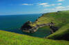
Boscastle Headlands

Boscastle Headlands
3.3 miles/5.3 km - Moderate
A circular walk from Boscastle to Pentargon waterfall and Willapark coastguard lookout with magnificent views of the village and harbour from the headlands where the village women once gathered dressed in red to fool a French ship into fleeing from British army redcoats.
-
5 miles/8 km - Moderate
Lesnewth to Tresparrett in the Valency Valley

Lesnewth to Tresparrett in the Valency Valley
5 miles/8 km - Moderate
A circular walk in the upper reaches of the River Valency above Boscastle, where author Thomas Hardy lived and met the love of his life, starting from the ancient Celtic church of Lesnewth to St Juliot church which Hardy restored.
-
5.5 miles/8.7 km - Moderate
Boscastle to Tintagel (via bus)

Boscastle to Tintagel (via bus)
5.5 miles/8.7 km - Moderate
A one-way coastal walk, made circular via an initial bus journey, along the dramatic coastline of islands and arches from Boscastle to Tintagel, rated as one of the top five walks in Cornwall.
-
6.2 miles/10 km - Moderate
Boscastle to Rocky Valley

Boscastle to Rocky Valley
6.2 miles/10 km - Moderate
A circular walk from Boscastle along the dramatic coastline of islands and arches towards Tintagel, following the cascading river up Rocky Valley past the ruined mills and labyrinthine carvings and returning via the mediaeval churches of Trethevy, Trevalga and Forrabury.
-
2.9 miles/4.6 km - Moderate-strenuous
Crackington Haven to St Genny's Church

Crackington Haven to St Genny's Church
2.9 miles/4.6 km - Moderate-strenuous
A circular walk from the surf beach at Crackington Haven to the mediaeval church at St Genny's via the imposing Penkenna Point, where there are spectacular views of the bay and the secluded landing points used by some of North Cornwall's most notorious smugglers and wreckers.
-
4.3 miles/6.9 km - Moderate-strenuous
Crackington Haven to The Strangles

Crackington Haven to The Strangles
4.3 miles/6.9 km - Moderate-strenuous
A circular walk from Crackington Haven, with panoramic views of the Shipwreck Coast, to the long, sandy Strangles beach, returning through bluebell woodland along the Ludon river valley.
-
4.9 miles/7.8 km - Moderate-strenuous
The Strangles to Buckator

The Strangles to Buckator
4.9 miles/7.8 km - Moderate-strenuous
A circular walk along the volcanic coastline north of Boscastle, including Cornwall's highest cliff and The Strangles beach with its spectacular arch known as the Northern Door.
-
5.4 miles/8.7 km - Moderate-strenuous
Boscastle to Buckator

Boscastle to Buckator
5.4 miles/8.7 km - Moderate-strenuous
A circular walk along the coastline from Boscastle via the Pentargon waterfall and the rugged cliffs at Buckator, returning along the Valency valley.
-
4.5 miles/7.3 km - Strenuous
St Gennys Church to Dizzard

St Gennys Church to Dizzard
4.5 miles/7.3 km - Strenuous
A circular walk at St Gennys from the mediaeval church, via the smuggling routes though bluebell woods along the stream and an Iron Age clifftop fort crumbling into the sea, to some of North Cornwall's most remote coastline.
-
7 miles/11.2 km - Strenuous
Crackington Haven to Boscastle (via bus)

Crackington Haven to Boscastle (via bus)
7 miles/11.2 km - Strenuous
A one-way coastal walk, made circular via an initial bus journey, along the Shipwreck Coast from Crackington Haven to Boscastle passing the highest cliff in Cornwall and the long, sandy beach at The Strangles.


Download the iWalk Cornwall app and use the QR scanner within the app to find out more about any of the walks above.
From Boscastle there are reasonably demanding coastal walks with spectacular scenery to Trevalga and Rocky Valley and to the Buckator seal colony which are both ideal to work up an appetite for a meal and make a full day out at Boscastle. There is also a much shorter and slightly less demanding walk along the Valency valley from Boscastle to Minster Church which passes close to all three of Boscastle's pubs on the return route and is also the ideal wild garlic foraging walk in Spring.
