Walks around St Austell
Enjoy the walks by being guided by the app


-
2.2 miles/3.6 km - Easy
Eden Project

Eden Project
2.2 miles/3.6 km - Easy
A walk though a granite landscape mined first for tin, then china clay and now for geothermal power to generate electricity and heat the space-age greenhouses of the Eden Project.
-
3.2 miles/5.2 km - Easy
King's Wood and Pentewan Valley

King's Wood and Pentewan Valley
3.2 miles/5.2 km - Easy
A circular walk through the King's Wood Woodland Trust reserve to the lost port of Pentewan, along the trackbed of the horse-drawn tramway that once carried china clay to the busy port and via the system of reservoirs and sluices that were used to flush sand out of the harbour.
-
3.5 miles/5.6 km - Easy
Par and Tywardreath

Par and Tywardreath
3.5 miles/5.6 km - Easy
A circular walk at Tywardreath where a mediaeval Priory was based and Par where much of the route was once a tidal creek and a wetland nature reserve has been created on some of the reclaimed land.
-
3.4 miles/5.5 km - Easy-moderate
Luxulyan Valley circular

Luxulyan Valley circular
3.4 miles/5.5 km - Easy-moderate
A circular walk following the leats and horse-drawn tramways through the World Heritage site of the Luxulyan Valley to the massive viaduct which carried the tramways towards Newquay and water to winch the trams up the valley with a huge waterwheel, recommended in guidebooks as early as the 1920s "as one of the most glorious walks in all Cornwall".
-
3.8 miles/6.1 km - Easy-moderate
Roche and the rock

Roche and the rock
3.8 miles/6.1 km - Easy-moderate
A circular walk at Roche where the spectacular remains of a mediaeval chapel are built into the towering rock outcrop and the villagers have defended public access to it with dynamite
-
5 miles/8 km - Easy-moderate
St Austell, Clay Trails and Menacuddle Well

St Austell, Clay Trails and Menacuddle Well
5 miles/8 km - Easy-moderate
A circular walk in china clay country, including a trail laid on the trackbed of a mineral railway from St Austell to the Cornish Alps and one of Cornwall's most picturesque holy wells.
-
5.8 miles/9.3 km - Easy-moderate
St Stephen and Tregargus Valley

St Stephen and Tregargus Valley
5.8 miles/9.3 km - Easy-moderate
A circular walk from St Stephen along a tributary valley of the River Fal to the hamlet of Coombe via some of Cornwall's best preserved remains of the Victorian and early 20th Century China Stone industry
-
2.9 miles/4.7 km - Moderate
Charlestown to Porthpean

Charlestown to Porthpean
2.9 miles/4.7 km - Moderate
A circular walk between the sheltered cove at Porthpean and the historic port of Charlestown, originally built to export copper, then China Clay, and now used for filming by Hollywood and Poldark.
-
3 miles/4.9 km - Moderate
Par Beach to Polkerris
Par Beach to Polkerris
3 miles/4.9 km - Moderate
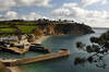
A circular walk on the coast path and Saint's Way from Par to the fishing hamlet of Polkerris where the pub has retreated into the Lifeboat station after being washed away by a storm in Victorian times, and Napoleonic cannons were built into the harbour wall as mooring posts.
-
3.6 miles/5.8 km - Moderate
Gribbin Head

Gribbin Head
3.6 miles/5.8 km - Moderate
A circular walk on the headland near Fowey where Daphne du Maurier lived and formed the basis for scenes in her books.
-
4.8 miles/7.7 km - Moderate
Grampound to Trenowth

Grampound to Trenowth
4.8 miles/7.7 km - Moderate
A circular walk in the Fal valley from Grampound which began as a river port in Roman times which evolved into the gateway into West Cornwall in mediaeval times and went on to become the centre of Cornwall's tanning industry.
-
4.8 miles/7.8 km - Moderate
Luxulyan Valley to Prideaux

Luxulyan Valley to Prideaux
4.8 miles/7.8 km - Moderate
A circular walk through the World Heritage site of the Luxulyan Valley and surrounding countryside, over the massive viaduct supporting a horse-drawn tram route to Newquay and along the leat that fed Charlestown Harbour.
-
5.3 miles/8.5 km - Moderate
Charlestown and Carlyon Bay

Charlestown and Carlyon Bay
5.3 miles/8.5 km - Moderate
A circular walk along the Cornish Riviera coastline frequented by royalty in the Roaring 20s, from the ingeniously-designed copper port now popular with film directors for its tall ships
-
6.2 miles/9.9 km - Moderate
Par and St Blazey

Par and St Blazey
6.2 miles/9.9 km - Moderate
A circular walk at Par where the land itself was created by the mining industry and is being re-sculpted by nature into sandy beaches, streams and woodland.
-
5.3 miles/8.5 km - Moderate-strenuous
Pentewan, Heligan and Mevagissey

Pentewan, Heligan and Mevagissey
5.3 miles/8.5 km - Moderate-strenuous
A circular walk from Pentewan to Mevagissey via The Lost Gardens of Heligan which were discovered in the 1990s after 7 decades of neglect and what followed The Times described as the garden restoration of the century.
-
6.7 miles/10.8 km - Moderate-strenuous
Polkerris, Gribbin Head and Readymoney Cove

Polkerris, Gribbin Head and Readymoney Cove
6.7 miles/10.8 km - Moderate-strenuous
A circular walk near Fowey, from the tiny harbour of Polkerris, past the daymark tower on Gribbin Head and along the coast where Daphne du Maurier lived and based many of her books on, to the sandy beach at Readymoney Cove, returning on the Saint's Way.
-
7.6 miles/12.3 km - Moderate-strenuous
Mevagissey to Charlestown (via bus)

Mevagissey to Charlestown (via bus)
7.6 miles/12.3 km - Moderate-strenuous
A one-way coastal walk, made circular via an initial bus journey, from the fishing port of Mevagissey to Charlestown - one of the best-preserved Georgian ports in the world and an engineering masterpiece which included a seven-mile-long leat.
-
5 miles/9 km - Strenuous
Porthpean to Black Head

Porthpean to Black Head
5 miles/9 km - Strenuous
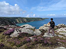
A circular walk from the sandy beach at Porthpean, past the brilliant white shingle beaches at Silvermine to the Iron Age fort on Black Head, returning via the site of an Iron Age metal works with spectacular views over St Austell Bay.
-
6.6 miles/10.6 km - Strenuous
Pentewan Valley and Black Head

Pentewan Valley and Black Head
6.6 miles/10.6 km - Strenuous
A circular walk from the lost port of Pentewan along the coast to the remains of the Iron Age fort overlooking St Austell Bay on Black Head, returning via the nature reserve that was once the King's wood and the trackbed of the horse-drawn tramway used for china clay and Sunday School outings.
Download the iWalk Cornwall app and use the QR scanner within the app to find out more about any of the walks above.