

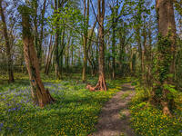
Woodland walks in Cornwall
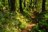
Enjoy the walks by being guided by the app


Woodland in Cornwall tends to be within sheltered valleys, so these walks are quite a good option to get out of the wind on a breezy day. The woodland is predominantly broadleaf so there are often celandines, bluebells and wild garlic in Spring.
-
1.8 miles/2.9 km - Easy
The Camelford Way

The Camelford Way
1.8 miles/2.9 km - Easy
A short and easy circular walk from Camelford along the wildflower-rich meadows of the River Camel to the clapper bridge at Fenteroon, returning through the fields with views over the Camel Valley.
-
2.9 miles/4.7 km - Easy
Helston

Helston
2.9 miles/4.7 km - Easy
A circular walk at Helston along the wooded valley of the River Cober and through the town via the church.
-
3.2 miles/5.2 km - Easy
King's Wood and Pentewan Valley

King's Wood and Pentewan Valley
3.2 miles/5.2 km - Easy
A circular walk through the King's Wood Woodland Trust reserve to the lost port of Pentewan, along the trackbed of the horse-drawn tramway that once carried china clay to the busy port and via the system of reservoirs and sluices that were used to flush sand out of the harbour.
-
4.2 miles/6.8 km - Easy
Constantine to Scott's Quay
Constantine to Scott's Quay
4.2 miles/6.8 km - Easy
A circular walk at Constantine through woods and to the creek on the Helford river where a bustling quarrying and mining industry operated in Victorian times but have now been reclaimed by nature.
-
5.3 miles/8.5 km - Easy
Dunmere to Grogley Halt

Dunmere to Grogley Halt
5.3 miles/8.5 km - Easy
A circular walk along the Camel valley from Dunmere Halt to Grogley Halt on the Camel Trail, passing the Camel Valley vineyard and the Boscarne platform where the Bodmin-Wenford steam trains depart.
-
2.2 miles/3.5 km - Easy-moderate
Lesnewth Church to Hallwell Woods

Lesnewth Church to Hallwell Woods
2.2 miles/3.5 km - Easy-moderate
A short circular walk in the tributary valleys of the River Valency through bluebell woodland beside a stream, and across meadows rich in wildflowers to the ancient Celtic churchyard of Lesnewth.
-
2.4 miles/3.9 km - Easy-moderate
St Tudy to Wetherham

St Tudy to Wetherham
2.4 miles/3.9 km - Easy-moderate
A circular countryside walk from the 15th century church at St Tudy through the grounds of the 18th century Manor of Wetherham, returning to the church alehouse where ale brewed by the church was sold to raise funds, and later became the village lock-up known as The Clink.
-
2.7 miles/4.4 km - Easy-moderate
Blisland to Lavethan Wood

Blisland to Lavethan Wood
2.7 miles/4.4 km - Easy-moderate
A short circular walk from the village of Blisland through the churchyard, two stretches of the Woodland Trust reserve of Lavethan Wood and land which was once the estates of Lavethan and Barlandew manors.
-
3.2 miles/5.1 km - Easy-moderate
Lanhydrock Gardens

Lanhydrock Gardens
3.2 miles/5.1 km - Easy-moderate
A fairly short and easy circular walk through Lanhydrock gardens with plenty of picnic spots along the River Fowey that you can combine with a visit to the house.
-
3.3 miles/5.2 km - Easy-moderate
St Keverne to Porthallow

St Keverne to Porthallow
3.3 miles/5.2 km - Easy-moderate
A circular walk through woods and meadows to Porthoustock and Porthallow from St Keverne, settled in the Dark Ages by Celtic monks trading with Brittany
-
3.3 miles/5.4 km - Easy-moderate
Towan Beach to Place House

Towan Beach to Place House
3.3 miles/5.4 km - Easy-moderate
A walk on contrasting coastlines, from the rugged Roseland coast to the sheltered creeks of the Percuil River opposite St Mawes.
-
3.4 miles/5.5 km - Easy-moderate
Luxulyan Valley circular

Luxulyan Valley circular
3.4 miles/5.5 km - Easy-moderate
A circular walk following the leats and horse-drawn tramways through the World Heritage site of the Luxulyan Valley to the massive viaduct which carried the tramways towards Newquay and water to winch the trams up the valley with a huge waterwheel, recommended in guidebooks as early as the 1920s "as one of the most glorious walks in all Cornwall".
-
3.6 miles/5.8 km - Easy-moderate
St Newlyn East and Lappa Valley

St Newlyn East and Lappa Valley
3.6 miles/5.8 km - Easy-moderate
A circular walk from St Newlyn East through the woods of the Lappa Valley where the Steam Railway now encompasses what was one of the most famous mines in Cornwall during Victorian times and the riverbeds are still stained red.
-
3.7 miles/5.9 km - Easy-moderate
Lerryn River and Tivoli lost gardens

Lerryn River and Tivoli lost gardens
3.7 miles/5.9 km - Easy-moderate
A woodland and riverside walk at Lerryn - thought to be the inspiration for the book The Wind In The Willows - and the lost pleasure gardens of Tivoli Park
-
3.7 miles/5.9 km - Easy-moderate
Newmills to Tregadillett

Newmills to Tregadillett
3.7 miles/5.9 km - Easy-moderate
A circular walk in the Kensey valley from the end of the steam railway at Newmills, through the bluebell woods at Trebursye, to the Eliot Arms in Tregadillett and returning to Newmills via the remains of a prehistoric fort, to catch the steam train back to Launceston.
-
3.7 miles/6 km - Easy-moderate
St Just-in-Roseland to Messack Point

St Just-in-Roseland to Messack Point
3.7 miles/6 km - Easy-moderate
A circular walk on the Roseland along both sides of St Just creek to Messack Point, where there are spectacular views over one of the largest natural harbours in the world.
-
3.8 miles/6.1 km - Easy-moderate
Lanhydrock to Respryn

Lanhydrock to Respryn
3.8 miles/6.1 km - Easy-moderate
A circular walk through the mature broadleaf woodland in the less well-known areas of the Lanhydrock estate, through bluebell woods and along the River Fowey, past the mediaeval bridge at Respryn, built after numerous prayers for safe passage in the ford-side chapel, had not resulted in the desired outcome.
-
3.8 miles/6.1 km - Easy-moderate
St Clement and Malpas

St Clement and Malpas
3.8 miles/6.1 km - Easy-moderate
A circular walk at the confluence of the Truro and Tresillian rivers, once defended by Moresk castle and later where timber for the mines was unloaded and floated as rafts into Truro
-
3.9 miles/6.2 km - Easy-moderate
Crowan to Clowance Estate

Crowan to Clowance Estate
3.9 miles/6.2 km - Easy-moderate
A circular walk in the parish of Crowan from the church to the Clowance Estate - the mansion of the St Aubyn Baronets until the fifth Baronet failed to produce a legitimate heir due to his 15 children all being born to women not married to him.
-
4.2 miles/6.8 km - Easy-moderate
Davidstow and Inny Vale

Davidstow and Inny Vale
4.2 miles/6.8 km - Easy-moderate
A circular walk in the Inny Vale on the northern edge of Bodmin Moor through the WW2 airbase on Davidstow Moor, the tunnel of trees to Treworra and past the source of the River Inny to the church and holy well of St David.
-
4.3 miles/7 km - Easy-moderate
Tehidy Woods to Deadman's Cove

Tehidy Woods to Deadman's Cove
4.3 miles/7 km - Easy-moderate
A circular walk through the wildlife reserve and bluebell woodland of Tehidy Country Park to Deadman's Cove and the North Cliffs, where many sailing ships were wrecked before the Godrevy Lighthouse was built.
-
4.4 miles/7 km - Easy-moderate
Giant's Quoit and Pendarves Wood

Giant's Quoit and Pendarves Wood
4.4 miles/7 km - Easy-moderate
A walk from a tiny village designed by Victorians, through ancient woodland that was once part of the Pendarves Estate to the prehistoric tomb that, despite two collapses over the centuries, is once again standing.
-
4.5 miles/7.2 km - Easy-moderate
Cardinham Woods and Lady Vale

Cardinham Woods and Lady Vale
4.5 miles/7.2 km - Easy-moderate
A circular walk in the wooded valley surrounding Cardinham Water where the mediaeval chapel of St Mary de Valle once stood but now only the Lady Vale mediaeval bridge remains.
-
5.1 miles/8.3 km - Easy-moderate
Deerpark to Herodsfoot

Deerpark to Herodsfoot
5.1 miles/8.3 km - Easy-moderate
A woodland walk in what's likely to have been a mediaeval deer park to the site of Cornwall's second-largest gunpowder manufacturing operation, which despite exploding several times was sufficiently successful to give rise to a nearby sister site known as Trago Mills.
-
about 5.1 miles/8.3 km - Easy-moderate
Helston and Cober Valley

Helston and Cober Valley
about 5.1 miles/8.3 km - Easy-moderate
A circular walk from Helston along the Cober Valley to the granite quarries at Coverack Bridges, where the viaduct of the Helston Railway can still be seen spanning the valley.
-
5.2 miles/8.4 km - Easy-moderate
Wadebridge to St Breock

Wadebridge to St Breock
5.2 miles/8.4 km - Easy-moderate
A circular walk from Wadebridge on the Camel Trail alongside the Amble Marshes nature reserve then across meadows and wooded creeks to the mediaeval church of St Breock, returning via the woods of the Polmorla valley.
-
5.9 miles/9.5 km - Easy-moderate
St Anthony Head

St Anthony Head
5.9 miles/9.5 km - Easy-moderate
A walk along the Roseland coast and creeks opposite St Mawes, passing the preserved fort and Fraggle Rock lighthouse on St Anthony Head and the golden sandy beaches of Molunan.
-
6 miles/9.6 km - Easy-moderate
Stithians to Kennall Vale

Stithians to Kennall Vale
6 miles/9.6 km - Easy-moderate
A circular walk in the valley of the River Kennall, where during Victorian times the cascading river was used to power gunpowder mills, five of which exploded in a chain reaction so violent that the roof of one was found a mile away.
-
6.1 miles/9.7 km - Easy-moderate
Egloshayle to Dinham Bridge

Egloshayle to Dinham Bridge
6.1 miles/9.7 km - Easy-moderate
A circular walk in the Allen Valley from Egloshayle though the broadleaf woodland alongside the River Allen past the mills of Hingham and Lemail, returning via the Celtic Three Holed Cross and the remains of Castle Killibury which from mediaeval Welsh texts is thought might be one of King Arthur's several castles.
-
6.1 miles/9.8 km - Easy-moderate
Golitha Falls and Siblyback Lake

Golitha Falls and Siblyback Lake
6.1 miles/9.8 km - Easy-moderate
A circular walk through the Golitha Falls National Nature Reserve along ancient rights of way to pass around Siblyback Lake, where the remains of a mediaeval field system rise from the water when reservoir levels fall.
-
6.2 miles/10 km - Easy-moderate
The Loe

The Loe
6.2 miles/10 km - Easy-moderate
A circular walk around the Loe Pool, the largest natural freshwater lake in Cornwall, and along the Loe Bar, one of Cornwall's most treacherous beaches on which 100 of those onboard the HMS Anson drowned metres from the shore, motivating the invention of the rocket lifesaving apparatus that saved thousands of lives.
-
6.6 miles/10.7 km - Easy-moderate
St Mawgan to St Columb Major

St Mawgan to St Columb Major
6.6 miles/10.7 km - Easy-moderate
A circular walk along the Vale of Lanherne to the mediaeval market town of St Columb Major, where Cornish Hurling is still played, through the broadleaf woodland of the Carnanton Estate along the River Menalhyl, returning to the riverside pub, church and convent at St Mawgan.
-
6.7 miles/10.8 km - Easy-moderate
Penryn Creeks and Enys

Penryn Creeks and Enys
6.7 miles/10.8 km - Easy-moderate
A circular walk along the creeks of Carrick Roads and through the woodland of the Enys Estate, famous for its bluebells in spring
-
6.8 miles/10.9 km - Easy-moderate
Wadebridge to Polbrock

Wadebridge to Polbrock
6.8 miles/10.9 km - Easy-moderate
A circular walk from Wadebridge through the Treraven nature reserve, bluebell woodland at Hustyn Mill and meadows along the River Camel to Polbrock, returning along the Camel Trail.
-
7.3 miles/11.7 km - Easy-moderate
Golitha Falls to Trethevy Quoit

Golitha Falls to Trethevy Quoit
7.3 miles/11.7 km - Easy-moderate
A circular walk through the Golitha Falls National Nature Reserve, to King Doniert's Stone - a memorial to the last King of Cornwall, and the prehistoric tomb of Trethevy Quoit, returning via St Cleer where the holy well is reputed to cure madness.
-
2.5 miles/4 km - Moderate
Danescombe Valley

Danescombe Valley
2.5 miles/4 km - Moderate
A circular walk from Cotehele Quay into the broadleaf woodland of the Danescombe Valley where bluebells and orchids flower in spring and fungi erupt through the carpet of autumn leaves.
-
2.6 miles/4.2 km - Moderate
Boscastle to Minster Church

Boscastle to Minster Church
2.6 miles/4.2 km - Moderate
A short circular walk from Boscastle through bluebell woodland alongside the River Valency to the ancient Celtic churchyard and sacred spring at Minster, returning along the River Jordan, beside which Bottreaux Castle was once situated, and Boscastle's Old Road.
-
2.7 miles/4.3 km - Moderate
Trebarwith Valley

Trebarwith Valley
2.7 miles/4.3 km - Moderate
A fairly short circular walk exploring Trebarwith Valley, a designated Area of Outstanding Natural Beauty in North Cornwall. The walk includes bluebell woodland, panoramic views from both sides of the valley and the Trebarwith Nature Reserve.
-
2.8 miles/4.5 km - Moderate
Two Coombes of Lansallos

Two Coombes of Lansallos
2.8 miles/4.5 km - Moderate
A circular walk from Lansallos to the coves of Lantivet Bay where farmers collected seaweed and sand to improve the soil and smugglers landed French brandy.
-
2.9 miles/4.7 km - Moderate
Week St Mary to Penhallam

Week St Mary to Penhallam
2.9 miles/4.7 km - Moderate
A circular walk from the Saxon village of Week St Mary through Ashbury woods, beneath the Iron Age fort, to the remains of the mediaeval manor of Penhallam which was only rediscovered in the 1960s, returning via the church, repaired after the pinnacle above the door was severed by lightning and crashed through the roof.
-
3 miles/4.8 km - Moderate
Millook to Trebarfoote

Millook to Trebarfoote
3 miles/4.8 km - Moderate
A circular walk through Woodland Trust reserves of the ancient Millook woods, meadows to the former smuggling den and 1920s wild party venue of Trebarfoote, and along the coast from Cancleave Strand to Millook Haven where colliding continents have melted and folded the rocks like toffee.
-
3.1 miles/4.9 km - Moderate
Kilminorth Woods and the Giant's Hedge

Kilminorth Woods and the Giant's Hedge
3.1 miles/4.9 km - Moderate
A woodland walk alongside the West Looe River where the Giant's Hedge once divided kingdoms of the Dark Ages, centuries before the ancient trees that now tower above it were even seedlings.
-
3.1 miles/5.0 km - Moderate
St Breward to Lank

St Breward to Lank
3.1 miles/5.0 km - Moderate
A short circular walk from St Breward through ancient bluebell woods along the valley of the River Camel to the holy well, ending at the mediaeval church and inn.
-
3.2 miles/5.2 km - Moderate
Helman Tor and Red Moor

Helman Tor and Red Moor
3.2 miles/5.2 km - Moderate
A circular walk to the neolithic enclosure on the summit of Helman Tor and through the woodland of Cornwall's largest nature reserve.
-
3.8 miles/6.1 km - Moderate
Helford and Frenchman's Creek

Helford and Frenchman's Creek
3.8 miles/6.1 km - Moderate
A circular walk through the wooded valleys of the Helford River including the most famous - Frenchman's Creek - which is still as pristine as when it inspired Daphne du Maurier's novel
-
3.9 miles/6.2 km - Moderate
Bossiney, St Nectan's Glen and Rocky Valley

Bossiney, St Nectan's Glen and Rocky Valley
3.9 miles/6.2 km - Moderate
A short circular walk through the woods of St Nectan's Glen and canyons of Rocky Valley, past the ruined mills and labyrinthine carvings, and along the coast to the golden sandy cove at Bossiney Haven.
-
3.9 miles/6.2 km - Moderate
Cotehele to Metherell

Cotehele to Metherell
3.9 miles/6.2 km - Moderate
A circular walk via the quays, woods, engine house and mills of the Cotehele Estate where by Georgian times the house had become a tourist attraction because it was so antiquated, and has changed little since.
-
4.2 miles/6.8 km - Moderate
St Dominic to Cotehele Bridge

St Dominic to Cotehele Bridge
4.2 miles/6.8 km - Moderate
A figure-of-eight walk from St Dominic along the wooded valley to the quays of Bohetherick and Cotehele, where limestone and coal were continuously fed into kilns to produce lime for the market gardens in the Tamar Valley.
-
4.3 miles/6.9 km - Moderate
Treslea Downs and Warleggan

Treslea Downs and Warleggan
4.3 miles/6.9 km - Moderate
A circular walk at one of Cornwall's more remote and eccentric hamlets, displaying a "twinned with Narnia" sign and with a church where the vicar surrounded his rectory with barbed wire and preached to an empty church containing name cards of his parishioners
-
4.4 miles/7.1 km - Moderate
Sandymouth to Coombe Valley

Sandymouth to Coombe Valley
4.4 miles/7.1 km - Moderate
A circular walk from Sandymouth beach, via the Landmark Trust's historic buildings of Coombe and a derelict mill which is one of the largest bat colonies in England, to the remains of the once great manor of Stowe Barton, the interior furnishings of which can be seen in Prideaux Place at Padstow.
-
4.5 miles/7.2 km - Moderate
Porth Reservoir and Colan church

Porth Reservoir and Colan church
4.5 miles/7.2 km - Moderate
A circular walk through the wildlife reserve around the reservoir lake, past crumbling ruins of Fir Hill Manor and via farmland, a mill and wooded vales that were also once part of the great estate.
-
4.7 miles/7.5 km - Moderate
Porthtowan to Chapel Porth

Porthtowan to Chapel Porth
4.7 miles/7.5 km - Moderate
A circular walk from Porthtowan, along the coast, valleys and woodland, passing engine houses and other relics of Cornish copper mining.
-
4.8 miles/7.7 km - Moderate
St Nectan's Glen and Trevillett Valley

St Nectan's Glen and Trevillett Valley
4.8 miles/7.7 km - Moderate
A circular walk from Bossiney through broadleaf woodland to the spectacular waterfall at St Nectan's Glen, returning through a wildlife area created from the old slate tips of Trevillett Quarry.
-
4.8 miles/7.8 km - Moderate
Luxulyan Valley to Prideaux

Luxulyan Valley to Prideaux
4.8 miles/7.8 km - Moderate
A circular walk through the World Heritage site of the Luxulyan Valley and surrounding countryside, over the massive viaduct supporting a horse-drawn tram route to Newquay and along the leat that fed Charlestown Harbour.
-
4.9 miles/7.8 km - Moderate
Ladock Woods and Holy Well

Ladock Woods and Holy Well
4.9 miles/7.8 km - Moderate
A circular walk from the woodland of The Duchy to the Holy Well of St Ladock in the river valley where in 1802 a gold nugget was found that contained enough gold to make an elegant necklace which is now in Truro museum.
-
5.1 miles/8.2 km - Moderate
Lerryn to St Winnow

Lerryn to St Winnow
5.1 miles/8.2 km - Moderate
A circular walk to the creekside church of St Winnow along the River Fowey and Lerryn where hoards of Roman coins have been found on the river banks, and overlooked by the manor house that is thought may have been the inspiration for Toad Hall in The Wind in the Willows.
-
5.2 miles/8.4 km - Moderate
Bodmin and Bodiniel - the two manors

Bodmin and Bodiniel - the two manors
5.2 miles/8.4 km - Moderate
A figure-of-8 walk through Bodmin's historic centre to the beacon nature reserve and through the woods at Dunmere to Scarlett's Well
-
5.3 miles/8.5 km - Moderate
Lanhydrock to Restormel

Lanhydrock to Restormel
5.3 miles/8.5 km - Moderate
A circular walk from the mediaeval bridge at Respryn along the River Fowey through the bluebell woodland of the Lanhydrock Estate to the circular Norman castle at Restormel which had a pressurised piped water system 700 years ahead of its time.
-
5.9 miles/9.5 km - Moderate
Cotehele to Calstock

Cotehele to Calstock
5.9 miles/9.5 km - Moderate
A circular walk through the gardens of Cotehele to Calstock where Cornwall's largest Roman fort once stood, the Vikings allied with the Cornish to fight off the Saxons, and more recently railway wagons were lifted over 100ft by steam power from the quay to the top of the viaduct.
-
6.1 miles/9.9 km - Moderate
Dunmere, Penhargard and Bodmin Jail

Dunmere, Penhargard and Bodmin Jail
6.1 miles/9.9 km - Moderate
A circular walk along the River Camel from Dunmere through bluebell woods and fields to Penhargard, and along an ancient route lined with wildflowers to Bodmin's historic jail.
-
6.2 miles/9.9 km - Moderate
Par and St Blazey
Par and St Blazey
6.2 miles/9.9 km - Moderate
A circular walk at Par where the land itself was created by the mining industry and is being re-sculpted by nature into sandy beaches, streams and woodland.
-
6.4 miles/10.3 km - Moderate
Pelynt and the West Looe Valley

Pelynt and the West Looe Valley
6.4 miles/10.3 km - Moderate
A circular walk in the West Looe valley to St Nun's Well where it is said that if a bent pin is not left as an offering, clouds of piskies will accompany the visitor home and cause mischief.
-
6.5 miles/10.5 km - Moderate
Duloe to Herodsfoot

Duloe to Herodsfoot
6.5 miles/10.5 km - Moderate
A circular walk through the woodland along the West Looe River to Herodsfoot from Duloe, where Cornwall's smallest stone circle stands.
-
3.7 miles/5.9 km - Moderate-strenuous
North Hill to Hawks Tor

North Hill to Hawks Tor
3.7 miles/5.9 km - Moderate-strenuous
A circular walk along prehistoric trade routes in the Lynher valley from the village of North Hill where the granite was quarried to build Westminster Bridge.
-
3.8 miles/6.1 km - Moderate-strenuous
Hall Walk from Fowey to Polruan

Hall Walk from Fowey to Polruan
3.8 miles/6.1 km - Moderate-strenuous
A circular version of the famous Hall Walk from Bodinnick to Polruan, recorded as a walk with "sweete senting flowers" in Tudor times and during the Civil War where a gun shot aimed at Charles I is said to have instead killed a fisherman who stood on the same spot moments later.
-
4.2 miles/6.8 km - Moderate-strenuous
Polruan to Lantic Bay

Polruan to Lantic Bay
4.2 miles/6.8 km - Moderate-strenuous
A circular walk along the coast from Polruan to the white sandy beaches of Lantic Bay, returning via Lanteglos Church and along the creek with panoramic views of Fowey.
-
4.3 miles/6.9 km - Moderate-strenuous
Crackington Haven to The Strangles

Crackington Haven to The Strangles
4.3 miles/6.9 km - Moderate-strenuous
A circular walk from Crackington Haven, with panoramic views of the Shipwreck Coast, to the long, sandy Strangles beach, returning through bluebell woodland along the Ludon river valley.
-
4.5 miles/7.2 km - Moderate-strenuous
Gunnislake to Chilsworthy

Gunnislake to Chilsworthy
4.5 miles/7.2 km - Moderate-strenuous
A circular walk in the Tamar Valley at Gunnislake where Victorian canal systems, engine houses and tramways have been recolonised by nature and kingfishers rather than barges now journey up and down the river.
-
4.5 miles/7.2 km - Moderate-strenuous
Rilla Mill and Plushabridge

Rilla Mill and Plushabridge
4.5 miles/7.2 km - Moderate-strenuous
A circular walk from Rilla Mill with views across Cornwall to the Cheesewring and Kit Hill, and along the River Lynher through the Colquite Woodland reserve and via medieval bridges to where the ancient mill stood until the 1960s and the leats can still be seen.
-
4.8 miles/7.7 km - Moderate-strenuous
Millook Haven to Dizzard

Millook Haven to Dizzard
4.8 miles/7.7 km - Moderate-strenuous
A circular walk through the Millook woodland reserves to the ancient gnarled oak forest of The Dizzard, returning along the coast with panoramic views to Hartland Point, to the chevron-folded cliffs and honeycomb reefs of Millook Haven.
-
5 miles/8 km - Moderate-strenuous
Kilkhampton to the Coombe valley

Kilkhampton to the Coombe valley
5 miles/8 km - Moderate-strenuous
A circular walk though the wildflowers of the Kilkhampton Common nature reserve and woods of the Coombe Valley, returning via the remains of the Norman castle at Penstowe which consisted of a stone tower perched on the top of a steep hill but surrounded by two baileys, rather than the usual one, the reason for which is a mystery.
-
5 miles/8.1 km - Moderate-strenuous
Lerryn to St Veep

Lerryn to St Veep
5 miles/8.1 km - Moderate-strenuous
A circular walk from Lerryn, along wooded creeks and across fields, to the church of St Veep, which is the only one in England where the bells were cast in perfect tune.
-
5.2 miles/8.4 km - Moderate-strenuous
Portreath and Tehidy Woods

Portreath and Tehidy Woods
5.2 miles/8.4 km - Moderate-strenuous
A circular walk along the rugged North Cliffs hiding smuggler's coves such as Ralph's Cupboard, to the sandy beach and historic mining port of Portreath, returning via the bluebell woodland of Illogan and Tehidy Country Park.
-
5.4 miles/8.7 km - Moderate-strenuous
Boscastle to Buckator

Boscastle to Buckator
5.4 miles/8.7 km - Moderate-strenuous
A circular walk along the coastline from Boscastle via the Pentargon waterfall and the rugged cliffs at Buckator, returning along the Valency valley.
-
5.4 miles/8.6 km - Moderate-strenuous
Duckpool to Woodford

Duckpool to Woodford
5.4 miles/8.6 km - Moderate-strenuous
A circular walk in Morwenstow parish along towering cliffs and through broadleaf woods where a hamlet has been preserved in a joint project between the Landmark Trust and National Trust
-
5 miles/9 km - Strenuous
Porthpean to Black Head

Porthpean to Black Head
5 miles/9 km - Strenuous
A circular walk from the sandy beach at Porthpean, past the brilliant white shingle beaches at Silvermine to the Iron Age fort on Black Head, returning via the site of an Iron Age metal works with spectacular views over St Austell Bay.
-
6.6 miles/10.6 km - Strenuous
Pentewan Valley and Black Head

Pentewan Valley and Black Head
6.6 miles/10.6 km - Strenuous
A circular walk from the lost port of Pentewan along the coast to the remains of the Iron Age fort overlooking St Austell Bay on Black Head, returning via the nature reserve that was once the King's wood and the trackbed of the horse-drawn tramway used for china clay and Sunday School outings.
-
7.1 miles/11.5 km - Strenuous
Polperro to Lansallos

Polperro to Lansallos
7.1 miles/11.5 km - Strenuous
A circular walk along the rugged coast from Polperro, where a bell buoy rings out across the waves from the treacherous reef known as Udder Rock.


Download the iWalk Cornwall app and use the QR scanner within the app to find out more about any of the walks above.
