

Walks in Mid Cornwall
Enjoy the walks by being guided by the app


-
1.9 miles/3 km - Easy
Park Head and Pentire Steps

Park Head and Pentire Steps
1.9 miles/3 km - Easy
A circular walk on Park Head, used as one of the filming locations in the Poldark BBC TV series and with spectacular views over Bedruthan Steps and the Trescore Islands.
-
2.2 miles/3.6 km - Easy
Eden Project

Eden Project
2.2 miles/3.6 km - Easy
A walk though a granite landscape mined first for tin, then china clay and now for geothermal power to generate electricity and heat the space-age greenhouses of the Eden Project.
-
3.2 miles/5.2 km - Easy
King's Wood and Pentewan Valley

King's Wood and Pentewan Valley
3.2 miles/5.2 km - Easy
A circular walk through the King's Wood Woodland Trust reserve to the lost port of Pentewan, along the trackbed of the horse-drawn tramway that once carried china clay to the busy port and via the system of reservoirs and sluices that were used to flush sand out of the harbour.
-
3.5 miles/5.6 km - Easy
Par and Tywardreath

Par and Tywardreath
3.5 miles/5.6 km - Easy
A circular walk at Tywardreath where a mediaeval Priory was based and Par where much of the route was once a tidal creek and a wetland nature reserve has been created on some of the reclaimed land.
-
4.3 miles/6.9 km - Easy
Mawgan Porth to St Mawgan

Mawgan Porth to St Mawgan
4.3 miles/6.9 km - Easy
A mostly circular walk from Mawgan Porth along the Vale of Lanherne, following the river Menalhyl to St Mawgan and returning past the 800-year-old cloistered Convent where the sanctuary light has been burning for hundreds of years.
-
2.2 miles/3.6 km - Easy-moderate
West Pentire and Polly Joke

West Pentire and Polly Joke
2.2 miles/3.6 km - Easy-moderate
A circular walk through the poppy fields of West Pentire to Polly Joke beach, returning over the headland to the pub that was a cowshed until the mid-20th Century.
-
2.3 miles/3.7 km - Easy-moderate
Crantock

Crantock
2.3 miles/3.7 km - Easy-moderate
A circular walk along the Gannel Estuary from Crantock Beach to Penpol Creek, returning though the village of Crantock.
-
3.2 miles/5.1 km - Easy-moderate
Lanhydrock Gardens

Lanhydrock Gardens
3.2 miles/5.1 km - Easy-moderate
A fairly short and easy circular walk through Lanhydrock gardens with plenty of picnic spots along the River Fowey that you can combine with a visit to the house.
-
3.3 miles/5.4 km - Easy-moderate
Towan Beach to Place House

Towan Beach to Place House
3.3 miles/5.4 km - Easy-moderate
A walk on contrasting coastlines, from the rugged Roseland coast to the sheltered creeks of the Percuil River opposite St Mawes.
-
3.4 miles/5.5 km - Easy-moderate
Luxulyan Valley circular

Luxulyan Valley circular
3.4 miles/5.5 km - Easy-moderate
A circular walk following the leats and horse-drawn tramways through the World Heritage site of the Luxulyan Valley to the massive viaduct which carried the tramways towards Newquay and water to winch the trams up the valley with a huge waterwheel, recommended in guidebooks as early as the 1920s "as one of the most glorious walks in all Cornwall".
-
3.4 miles/5.4 km - Easy-moderate
St Anthony Head (short version)

St Anthony Head (short version)
3.4 miles/5.4 km - Easy-moderate
A walk on the Roseland coast and then into the Fal estuary to St Anthony Church via the fort St Anthony Head and the golden sandy beaches of Molunan.
-
3.6 miles/5.8 km - Easy-moderate
Lost Church and Perranporth dunes

Lost Church and Perranporth dunes
3.6 miles/5.8 km - Easy-moderate
A circular walk on the highest dune system in Britain to the chapel dating from Celtic times which was lost in the dunes for nearly 1000 years.
-
3.6 miles/5.8 km - Easy-moderate
St Newlyn East and Lappa Valley

St Newlyn East and Lappa Valley
3.6 miles/5.8 km - Easy-moderate
A circular walk from St Newlyn East through the woods of the Lappa Valley where the Steam Railway now encompasses what was one of the most famous mines in Cornwall during Victorian times and the riverbeds are still stained red.
-
3.7 miles/5.9 km - Easy-moderate
Restormel Castle and Lostwithiel
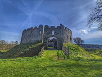
Restormel Castle and Lostwithiel
3.7 miles/5.9 km - Easy-moderate
A circular walk to the mediaeval capital of Cornwall from one of its most striking Norman castles along the valley where Victoria and Albert tried their hand at mining and members of the Royal family still sometimes visit.
-
3.7 miles/6 km - Easy-moderate
St Just-in-Roseland to Messack Point

St Just-in-Roseland to Messack Point
3.7 miles/6 km - Easy-moderate
A circular walk on the Roseland along both sides of St Just creek to Messack Point, where there are spectacular views over one of the largest natural harbours in the world.
-
3.8 miles/6.1 km - Easy-moderate
Lanhydrock to Respryn

Lanhydrock to Respryn
3.8 miles/6.1 km - Easy-moderate
A circular walk through the mature broadleaf woodland in the less well-known areas of the Lanhydrock estate, through bluebell woods and along the River Fowey, past the mediaeval bridge at Respryn, built after numerous prayers for safe passage in the ford-side chapel, had not resulted in the desired outcome.
-
3.9 miles/6.2 km - Easy-moderate
Holywell to Polly Joke

Holywell to Polly Joke
3.9 miles/6.2 km - Easy-moderate
A circular walk from Holywell Bay on the dunes and Kelsey Head to the sandy beach of Polly Joke.
-
4 miles/6.4 km - Easy-moderate
Watergate Bay to Newquay (via bus)

Watergate Bay to Newquay (via bus)
4 miles/6.4 km - Easy-moderate
A one-way coastal walk, made circular via an initial bus journey, from Watergate Bay along the coast path to Newquay, passing the sea caves at Whipsiderry beach, the Iron Age hillfort on Trevelgue head and the beaches of Porth, Lusty Glaze and Tolcarne.
-
4.5 miles/7.2 km - Easy-moderate
Crantock and The Gannel

Crantock and The Gannel
4.5 miles/7.2 km - Easy-moderate
A circular walk along the River Gannel from Crantock, originally settled by Celtic monks whose chapel is thought may be buried beneath the dunes.
-
4.7 miles/7.5 km - Easy-moderate
Holywell to Crantock

Holywell to Crantock
4.7 miles/7.5 km - Easy-moderate
A circular walk from Holywell Bay past the remarkable sacred spring and along the coast to the sandy beaches of Porth Joke and Crantock, returning via the poppy fields of West Pentire and the Cubert Common nature conservation area.
-
5 miles/8 km - Easy-moderate
St Austell, Clay Trails and Menacuddle Well

St Austell, Clay Trails and Menacuddle Well
5 miles/8 km - Easy-moderate
A circular walk in china clay country, including a trail laid on the trackbed of a mineral railway from St Austell to the Cornish Alps and one of Cornwall's most picturesque holy wells.
-
5.8 miles/9.3 km - Easy-moderate
Castle-an-dinas and Menalhyl valley

Castle-an-dinas and Menalhyl valley
5.8 miles/9.3 km - Easy-moderate
A mostly circular walk from the Castle-an-dinas Iron Age hillfort with 360 degree views across Cornwall, then into the valley to the River Menalhyl, followed by wooded paths lined with primroses, bluebells and wild garlic, and lanes with vibrant wildflowers.
-
5.8 miles/9.3 km - Easy-moderate
St Stephen and Tregargus Valley

St Stephen and Tregargus Valley
5.8 miles/9.3 km - Easy-moderate
A circular walk from St Stephen along a tributary valley of the River Fal to the hamlet of Coombe via some of Cornwall's best preserved remains of the Victorian and early 20th Century China Stone industry
-
5.9 miles/9.5 km - Easy-moderate
St Anthony Head

St Anthony Head
5.9 miles/9.5 km - Easy-moderate
A walk along the Roseland coast and creeks opposite St Mawes, passing the preserved fort and Fraggle Rock lighthouse on St Anthony Head and the golden sandy beaches of Molunan.
-
6.6 miles/10.7 km - Easy-moderate
St Mawgan to St Columb Major

St Mawgan to St Columb Major
6.6 miles/10.7 km - Easy-moderate
A circular walk along the Vale of Lanherne to the mediaeval market town of St Columb Major, where Cornish Hurling is still played, through the broadleaf woodland of the Carnanton Estate along the River Menalhyl, returning to the riverside pub, church and convent at St Mawgan.
-
2.9 miles/4.7 km - Moderate
Charlestown to Porthpean
Charlestown to Porthpean
2.9 miles/4.7 km - Moderate
A circular walk between the sheltered cove at Porthpean and the historic port of Charlestown, originally built to export copper, then China Clay, and now used for filming by Hollywood and Poldark.
-
3 miles/4.9 km - Moderate
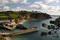
Par Beach to Polkerris
Par Beach to Polkerris
3 miles/4.9 km - Moderate
A circular walk on the coast path and Saint's Way from Par to the fishing hamlet of Polkerris where the pub has retreated into the Lifeboat station after being washed away by a storm in Victorian times, and Napoleonic cannons were built into the harbour wall as mooring posts.
-
3.2 miles/5.2 km - Moderate
Helman Tor and Red Moor

Helman Tor and Red Moor
3.2 miles/5.2 km - Moderate
A circular walk to the neolithic enclosure on the summit of Helman Tor and through the woodland of Cornwall's largest nature reserve.
-
3.3 miles/5.3 km - Moderate
Readymoney Cove to Polridmouth

Readymoney Cove to Polridmouth
3.3 miles/5.3 km - Moderate
A circular walk in du Maurier country from Readymoney Cove - where she lived in the 1940s - to Polridmouth, where the shipwreck inspired her book Rebecca.
-
3.4 miles/5.4 km - Moderate
Mevagissey to Portmellon

Mevagissey to Portmellon
3.4 miles/5.4 km - Moderate
A circular walk from the busy fishing port of Mevagissey into the Portmellon Valley and through the West Bodrugan Woods nature reserve to the beachside village of Portmellon where boats have been built for hundreds of years, and still are.
-
3.5 miles/5.7 km - Moderate
West Pentire to Crantock Beach

West Pentire to Crantock Beach
3.5 miles/5.7 km - Moderate
A circular walk on the northernmost end of one of Cornwall's largest areas of sand dunes that stretch from Crantock to Perranporth, under which one mediaeval chapel was found and another is said to still be lost.
-
3.6 miles/5.8 km - Moderate
Gribbin Head

Gribbin Head
3.6 miles/5.8 km - Moderate
A circular walk on the headland near Fowey where Daphne du Maurier lived and formed the basis for scenes in her books.
-
4 miles/6.4 km - Moderate
Towan Beach to Portscatho

Towan Beach to Portscatho
4 miles/6.4 km - Moderate
A circular walk on the Roseland coast where, during the Napoleonic Wars, smugglers would row out to the middle of The Channel in pilot gigs to trade with the enemy.
-
4.4 miles/7 km - Moderate
Portscatho to Pendower Beach

Portscatho to Pendower Beach
4.4 miles/7 km - Moderate
A circular walk along two miles of beaches around Gerrans Bay which were once used by Portscatho smugglers to land contraband and strewn with the wreckage of sailing ships that overshot Falmouth Harbour and ran aground on The Whelps reef.
-
4.5 miles/7.3 km - Moderate
Bedruthan Steps

Bedruthan Steps
4.5 miles/7.3 km - Moderate
A circular walk with spectacular views of the rock stacks at Bedruthan Steps, about which the myth of a giant's stepping stones was concocted for the amusement of Victorian tourists flocking to Padstow and Newquay on the new railway.
-
4.5 miles/7.2 km - Moderate
Porth Reservoir and Colan church

Porth Reservoir and Colan church
4.5 miles/7.2 km - Moderate
A circular walk through the wildlife reserve around the reservoir lake, past crumbling ruins of Fir Hill Manor and via farmland, a mill and wooded vales that were also once part of the great estate.
-
4.7 miles/7.6 km - Moderate
Fowey to Polridmouth

Fowey to Polridmouth
4.7 miles/7.6 km - Moderate
A figure-of-eight walk from Readymoney Cove past the Tudor fort and along the coast where Daphne du Maurier lived to Polridmouth, where the shipwreck inspired the end of her book Rebecca, and then along the mediaeval streets of Fowey.
-
4.7 miles/7.5 km - Moderate
Perranporth to St Agnes (via bus)

Perranporth to St Agnes (via bus)
4.7 miles/7.5 km - Moderate
A one-way coastal walk, made circular via an initial bus journey, along the ore-bearing cliffs between Perranporth and St Agnes passing the remains of Nobel's dynamite works, Britain's best preserved spitfire base and the Blue Hills of Trevellas Coombe where tin is still processed on a small scale using traditional methods.
-
4.8 miles/7.7 km - Moderate
Grampound to Trenowth

Grampound to Trenowth
4.8 miles/7.7 km - Moderate
A circular walk in the Fal valley from Grampound which began as river port in Roman times which evolved into the gateway into West Cornwall in mediaeval times and went on to become the centre of Cornwall's tanning industry.
-
4.8 miles/7.8 km - Moderate
Luxulyan Valley to Prideaux

Luxulyan Valley to Prideaux
4.8 miles/7.8 km - Moderate
A circular walk through the World Heritage site of the Luxulyan Valley and surrounding countryside, over the massive viaduct supporting a horse-drawn tram route to Newquay and along the leat that fed Charlestown Harbour.
-
4.9 miles/7.9 km - Moderate
Gorran Haven to Dodman Point

Gorran Haven to Dodman Point
4.9 miles/7.9 km - Moderate
A circular walk in the bays of Mevagissey and Veryan from the fishing village of Gorran Haven to the remote, sandy Hemmick Beach via The Deadman's Point of old nautical maps, still marked with a huge cross to warn sailors of the perilous lee shores, and Vault Beach where the wreckage washed ashore.
-
4.9 miles/7.8 km - Moderate
Ladock Woods and Holy Well

Ladock Woods and Holy Well
4.9 miles/7.8 km - Moderate
A circular walk from the woodland of The Duchy to the Holy Well of St Ladock in the river valley where in 1802 a gold nugget was found that contained enough gold to make an elegant necklace which is now in Truro museum.
-
5.3 miles/8.5 km - Moderate
Callestick and Ventongimps

Callestick and Ventongimps
5.3 miles/8.5 km - Moderate
A circular countryside walk past the nature reserve at Ventongimps and the engine house of West Chyverton mine, with refreshment opportunities at both Callestick Farm, where you can see the ice cream being made, and Healey's Cyder Farm who offer tours and tasting.
-
5.3 miles/8.5 km - Moderate
Charlestown and Carlyon Bay

Charlestown and Carlyon Bay
5.3 miles/8.5 km - Moderate
A circular walk along the Cornish Riviera coastline frequented by royalty in the Roaring 20s, from the ingeniously-designed copper port now popular with film directors for its tall ships
-
5.3 miles/8.5 km - Moderate
Lanhydrock to Restormel

Lanhydrock to Restormel
5.3 miles/8.5 km - Moderate
A circular walk from the mediaeval bridge at Respryn along the River Fowey through the bluebell woodland of the Lanhydrock Estate to the circular Norman castle at Restormel which had a pressurised piped water system 700 years ahead of its time.
-
5.3 miles/8.5 km - Moderate
Pendower Beach to Veryan

Pendower Beach to Veryan
5.3 miles/8.5 km - Moderate
A circular walk from Pendower Beach to Veryan via Nare Head where, in Victorian times, an unhappily married fisherman lived alone in a cliff-edge cottage, lowering his boat on a rope over the cliff and returning once a week to Veryan to bring his wife fish.
-
5.4 miles/8.7 km - Moderate
Perranporth to Trevellas

Perranporth to Trevellas
5.4 miles/8.7 km - Moderate
A circular walk past the remains of Alfred Nobel's dynamite works to the red-and-yellow ore-rich cliffs above the wreck of the treasure ship Hanover, returning, via the spitfire base, along Perran Coombe where a 2-mile leat once carried water to power a massive waterwheel in a chamber within the cliffs.
-
5.8 miles/9.3 km - Moderate
Newquay

Newquay
5.8 miles/9.3 km - Moderate
A circular walk around the UK's surf capital which was transformed from a tiny fishing village with a few thatched cottages when, in order to export ore from the harbour, a horse-drawn tramway was built across Cornwall which later became part of the Great Western Railway.
-
5.9 miles/9.6 km - Moderate
Gorran Haven to Portmellon

Gorran Haven to Portmellon
5.9 miles/9.6 km - Moderate
A circular walk from Gorran Haven to Portmellon via the sheer cliffs from which Henry Bodrugan leapt to escape execution and sheltered Colona Beach, returning through West Bodrugan Woods Nature Reserve and via Gorran church which now has some of the finest bells in the country.
-
6.2 miles/10 km - Moderate
Bedruthan Steps to Porthcothan

Bedruthan Steps to Porthcothan
6.2 miles/10 km - Moderate
A circular walk featuring some of the most spectacular scenery of the North Cornish coast including the rock stacks of Bedruthan Steps, the azure lagoon of the Trescore Islands and the sheltered golden sandy beach at Porthcothan.
-
6.2 miles/9.9 km - Moderate
Par and St Blazey
Par and St Blazey
6.2 miles/9.9 km - Moderate
A circular walk at Par where the land itself was created by the mining industry and is being re-sculpted by nature into sandy beaches, streams and woodland.
-
6.8 miles/11.0 km - Moderate
Porthcothan, Bedruthan Steps and Watergate Bay (via bus)
Porthcothan, Bedruthan Steps and Watergate Bay (via bus)
6.8 miles/11.0 km - Moderate
A (bus-assisted) one-way walk along the coast with spectacular wildflowers and one of Cornwall's most photographed views over the volcanic rock stacks of Bedruthan Steps, which Victorians liked to think of as a giant's stepping stones.
-
6.9 miles/11.2 km - Moderate
Holywell Bay to Newquay (via bus)

Holywell Bay to Newquay (via bus)
6.9 miles/11.2 km - Moderate
A one-way coastal walk, made circular via an initial bus journey, from Holywell Bay along the coast and Gannel estuary to Newquay, passing the beaches of Porth Joke and Crantock and the headland of West Pentire where there is a spectacular display of red-and-gold wildflowers in June.
-
7.4 miles/11.9 km - Moderate
Holywell to St Piran's Oratory

Holywell to St Piran's Oratory
7.4 miles/11.9 km - Moderate
A circular walk from Holywell Bay along the rugged coastline to Perran Beach and across the dunes to the mediaeval relics of St Piran's Oratory, Church and Cross, returning via the Penhale Sands nature reserve which is carpeted in cowslips during spring.
-
3.8 miles/6.1 km - Moderate-strenuous
Caerhays Castle to Hemmick Beach

Caerhays Castle to Hemmick Beach
3.8 miles/6.1 km - Moderate-strenuous
A circular walk around Veryan Bay between two sandy beaches from Caerhays Castle where the gardens contain nationally-important collections from the expeditions of Victorian plant hunters
-
3.8 miles/6.1 km - Moderate-strenuous
Hall Walk from Fowey to Polruan

Hall Walk from Fowey to Polruan
3.8 miles/6.1 km - Moderate-strenuous
A circular version of the famous Hall Walk from Bodinnick to Polruan, recorded as a walk with "sweete senting flowers" in Tudor times and during the Civil War where a gun shot aimed at Charles I is said to have instead killed a fisherman who stood on the same spot moments later.
-
3.9 miles/6.3 km - Moderate-strenuous
Portholland to Portloe

Portholland to Portloe
3.9 miles/6.3 km - Moderate-strenuous
A circular walk with lovely views of Veryan Bay to the pretty fishing village of Portloe from West Portholland, where one of the last of Cornwall's mediaeval coastal farmsteads has survived.
-
5.2 miles/8.3 km - Moderate-strenuous
Nare Head to Portloe

Nare Head to Portloe
5.2 miles/8.3 km - Moderate-strenuous
A circular walk around Nare Head, past the restored Cold War nuclear bunker, to the pretty fishing village of Portloe, with views along the length of The Roseland coast and over The Whelps reef - a graveyard for sailing ships that misjudged the entrance to Falmouth.
-
5.3 miles/8.5 km - Moderate-strenuous
Pentewan, Heligan and Mevagissey

Pentewan, Heligan and Mevagissey
5.3 miles/8.5 km - Moderate-strenuous
A circular walk from Pentewan to Mevagissey via The Lost Gardens of Heligan which were discovered in the 1990s after 7 decades of neglect and what followed The Times described as the garden restoration of the century.
-
6.4 miles/10.3 km - Moderate-strenuous
Cubert to St Piran's Round

Cubert to St Piran's Round
6.4 miles/10.3 km - Moderate-strenuous
A circular walk from Cubert's Celtic churchyard through the cowslip meadows of the Penhale Sands nature reserve and on paths lined with wildflowers along the river valley to reach St Piran's Round - the remains of the mediaeval amphitheatre.
-
6.7 miles/10.8 km - Moderate-strenuous
Polkerris, Gribbin Head and Readymoney Cove

Polkerris, Gribbin Head and Readymoney Cove
6.7 miles/10.8 km - Moderate-strenuous
A circular walk near Fowey, from the tiny harbour of Polkerris, past the daymark tower on Gribbin Head and along the coast where Daphne du Maurier lived and based many of her books on, to the sandy beach at Readymoney Cove, returning on the Saint's Way.
-
7.6 miles/12.3 km - Moderate-strenuous
Mevagissey to Charlestown (via bus)

Mevagissey to Charlestown (via bus)
7.6 miles/12.3 km - Moderate-strenuous
A one-way coastal walk, made circular via an initial bus journey, from the fishing port of Mevagissey to Charlestown - one of the best-preserved Georgian ports in the world and an engineering masterpiece which included a seven-mile-long leat.
-
5 miles/9 km - Strenuous
Porthpean to Black Head

Porthpean to Black Head
5 miles/9 km - Strenuous
A circular walk from the sandy beach at Porthpean, past the brilliant white shingle beaches at Silvermine to the Iron Age fort on Black Head, returning via the site of an Iron Age metal works with spectacular views over St Austell Bay.
-
6.6 miles/10.6 km - Strenuous
Pentewan Valley and Black Head

Pentewan Valley and Black Head
6.6 miles/10.6 km - Strenuous
A circular walk from the lost port of Pentewan along the coast to the remains of the Iron Age fort overlooking St Austell Bay on Black Head, returning via the nature reserve that was once the King's wood and the trackbed of the horse-drawn tramway used for china clay and Sunday School outings.


Download the iWalk Cornwall app and use the QR scanner within the app to find out more about any of the walks above.
