

Crooklets beach
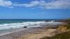
Crooklets is a sandy beach with pebbles near the top and areas of rocks either side. There is a beach at all states of the tide. As the tide goes out, Crooklets merges with Summerleaze beach. There are some ridges of rock between Summerleaze beach and Crooklets interspersed with areas of sand.
On a really low tide once the sea recedes beyond Wrangle Point, Crooklets merges with the Mear Cliff beaches to the north and eventually Northcott Mouth beyond these.
Circular walks visiting Crooklets beach
-
3.5 miles/5.6 km - Easy
Bude to Northcott Mouth

Bude to Northcott Mouth
3.5 miles/5.6 km - Easy
A circular walk past the Sea Pool to Crooklets beach and along Maer cliff to the beach at Northcott Mouth, where the shipwreck of the SS Belem is exposed at low tide.
-
3.9 miles/6.3 km - Easy
Bude Canal and Coast

Bude Canal and Coast
3.9 miles/6.3 km - Easy
A figure-of-8 walk at Bude where the demand for lime-rich sand could not even be met by 4000 horses a day and so a 35-mile canal was built to transport it to the Tamar Valley.
-
6.2 miles/10 km - Moderate
Bude to Sandymouth

Bude to Sandymouth
6.2 miles/10 km - Moderate
A circular walk through Bude and along two miles of sandy beaches to Sandymouth, passing Bude Castle, built on floating foundations by the inventor of limelight, the Victorian Sea Pool, the Half-Tide Cross and the shipwreck of the SS Belem from which the propeller shaft supports the barrel on Barrel Rock.


Download the iWalk Cornwall app and use the QR scanner within the app to find out more about any of the walks above.